Tuesday, 18 September 2012

Alice Springs


(Magyar összefoglaló a végén)

Tuesday, 11 Sep, Alice Springs - We left the Kings Canyon Resort early and travelled to Alice Springs, through the Lasseter and Stuart Hwy, about 500 kms. We got here by about 1.30 pm for a late lunch, a bit of rest, then a quick drive-around the town centre, looking for some important business, such as a hair cut for Kate that was well overdue, and some shopping as well. It seems we came back to the summer weather, at least at lunchtime there was 30 degrees in the van - we'll see what happens during the night...

The town centre and the Gap from ANZAC Hill
Wednesday, 12 Sep, Alice Springs - The night was quite cold again, it was 11 degrees in the van at dawn. This place has a climate of extremes, early afternoon it was 34 degrees again, and the humidity is not more than 20 %. We have to change clothes 3 times a day according to the changes in temperature. 
In the morning we went up to ANZAC Hill, just beside the town centre. Beside the war memorial it has wonderful views all over the town and surroundings. The MacDonnel Ranges and the Gap where the Todd river passes through are very impressive from up there. We drove across and along the river, which now is a wide dry sandy bed with some beautiful river gums here and there but can be a torrent after the rare heavy rain.
John Flynn Memorial Church
We walked around the centre to discover some historical buildings: the Rev John Flynn Memorial Church (the founder of the Royal Flying Doctor Service), the Adelaide House (the first hospital in central Australia, also designed and established by Flynn), the government residency (where the Queen and her husband stayed at their visit in 1963), and the Old Hartley Street School opened in 1930.
Adelaide House
In the Botanic Gardens
In the (very hot) afternoon we had the car washed, not an easy job after several months of red dirt, then went out to the Botanic Gardens in the hope of an evening performance as part of the Desert Festival. In the end we did not stay for the event, but had a look around in the garden, and learned about the life of Olive Pink a very determined lady, a painter and anthropologist, who studied the aboriginals in the area and fought for their rights against the establishments in the 1930s. She was also the first curator of the Botanic Gardens.

Thursday, 13 Sep, Alice Springs - This morning we got a bad surprise: our 3-way fridge is not working on 240 Volt. So we had to call a service and we were lucky enough that he came within an hour (also lucky that it happened here, not somewhere in the middle of nowhere). He worked on it for 2 hours, but he did not find the cause of the problem. Now we have to try it on gas and see if it works, then, depending on the outcome, he can finish it tomorrow - hopefully. 
Telegraph Station
In the rest of the morning we went out to visit the Old Telegraph Station beside the Todd River, which was in fact more than that, it was a little village, the first European settlement in Central Australia. There are many buildings beautifully restored and lots of info displays explaining the history and use of the buildings. There were a group of school children on excursion out there, studying the early life, doing some projects and, mostly, playing cricket with their male teachers. It was an interesting place, and an enjoyable visit.
Telegraph Station
In the afternoon we had a lot of cooking to do, all our stocks in the freezer that thawed we had to cook and fry, so now we will have a lot of meat and fish to eat in the next few days...
The Night Market on Todd Mall
Then around 6 pm we went into the town centre to visit the Night Market, an event of the Desert Festival. It was not such a big deal, just the usual things on such markets, cheap artefacts, clothes, toys, lots of useless but nice things, food and drinks. 
It seems colourful baby ballerina dresses are much in demand in Alice Springs, at least there was a wide collection on offer... 
A popular activity in AS
Night Market
The people walking around were just as colourful and interesting as the articles. Fortunately the crowd was much less than the 50 thousand expected in one of the festival brochures ...

Our itinerary can be seen at the following Google Map:
http://g.co/maps/wcwv8 
(Note that to see the route after Bowen, you need to move down to the bottom of the left panel, and select the following pages!)


A múlt hét nagyrészét Alice Springs-ben töltöttük, nem egészen saját jószántunkból. Kedden (szep.11) érkeztünk ide, és szerdán észrevettük hogy nem hűt a fridzsiderünk, ami pedig létfontosságú az utazáshoz. Még szerencse hogy itt történt és nem valahol a pusztában, mert itt ki tudtunk hívni egy szervizt (még garanciális minden a lakókocsinkban), és elég gyorsan ki is jöttek, de eltartott két napig míg megállapították hogy a termosztát romlott el, ami viszont nincs nekik itt raktáron, meg kellett rendelni a gyártó cégtől, és még most is várunk rá hogy megérkezzen. Most ideiglenesen kiiktatták a termosztátot, úgyhogy most működik a fridzs, csak teljes erővel, vagyis néha kicsit csonttá fagy benne minden, amit próbálunk elkerülni úgy hogy néha lekapcsoljuk pár órára. Szóval még nem vagyunk túl ezen az ügyön, jövő héten remélhetőleg sikerül megoldani. Persze kiolvadt minden ami a mélyhűtőben volt, nekiálltunk mindent megfőzni-sütni, azóta is azokat esszük.
Ettől eltekintve kellemes napokat töltöttünk Alice Springs-ben, ami meglepően helyes kisváros itt a sivatag közepén. Nem is olyan kicsi, vagy 30ezer lakosa van, nemiegn tudom elképzelni miből is élnek meg itt. Végigjártuk a helyi látnivalókat, kilátó pontot, várostörténeti érdekességeket városon belül és kívül. A legérdekesebb a régi telegráf állomás, az 1870-es évekből, ami egész kis település volt, az első fehérek-lakta hely közép-Ausztráliában. Szépen rende van hozva, és sok érdekes információs tábla ismerteti a történetét. Megnéztük az Adelaide House-t, az első korház az 1920-as évekből, egy presbiter(?) pap, John Flynn szorgalmazta, tervezte és építtette (ő alapította a Royal Flying Doctor szervizt is). Láttuk a Government House-t, ahol 63-ban a királyi pár lakott amikor idelátogattak. Voltunk a botanikus kertben, amit egy helybeli "pionir" hölgy kezdeményezett. Pont most tartanak itt egy Desert Festival-t, aminek keretében mindenféle programok látogathatók, mi elmentünk a csütörtök esti utcavásárra, ami érdekes volt de nem valami nagy szám.


Az útvonalunk a következo Google Map-on látható:
http://g.co/maps/wcwv8
(A Bowen utáni szakaszokhoz le kell menni a baloldali panel aljára, és a következo oldalakra kattintani!!)

Tuesday, 11 September 2012

Kings Canyon


(Magyar összefoglaló a végén)

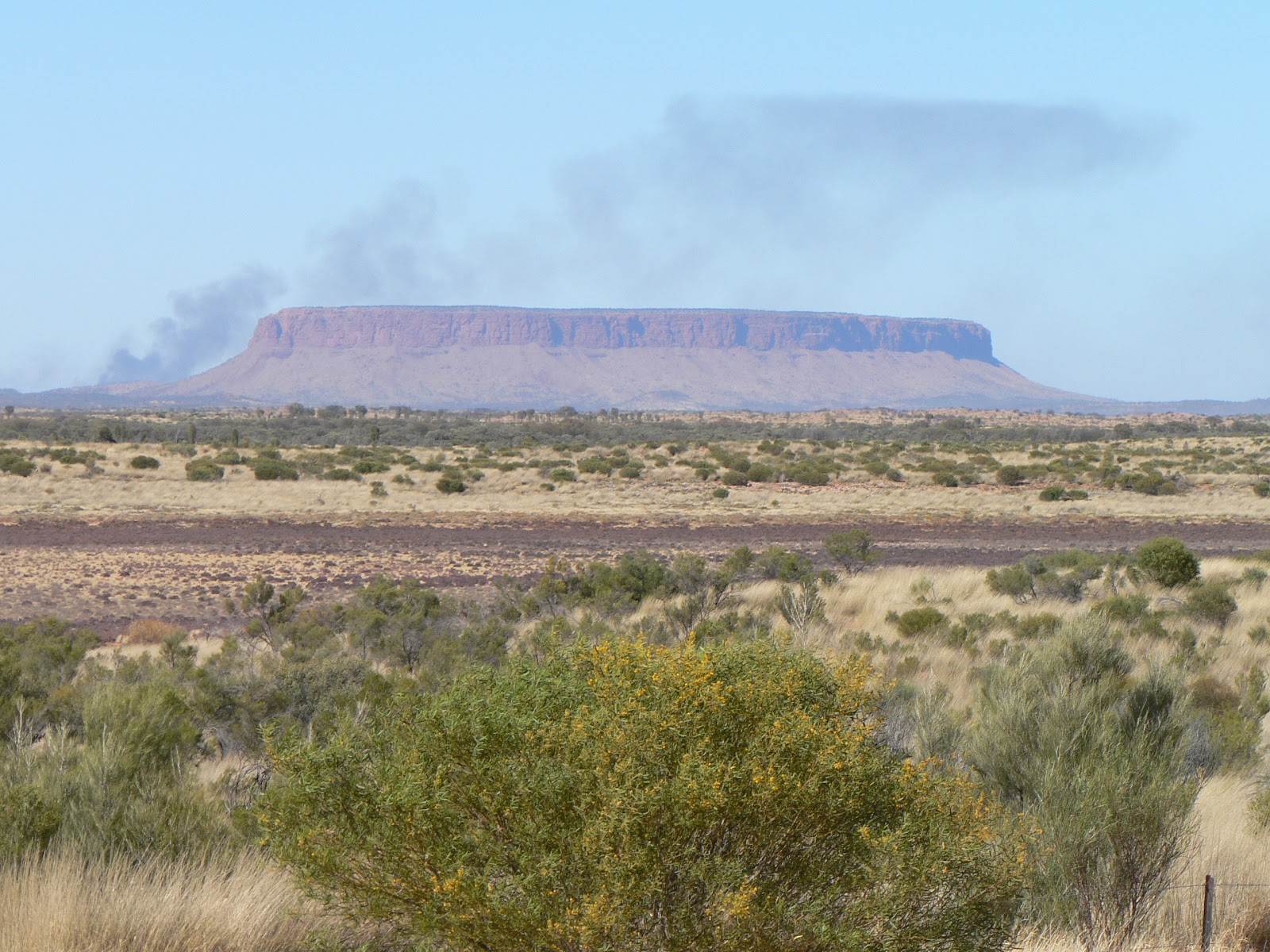
Mt Conner
Saturday, 8 Sep, Kings Canyon Resort - In the morning we left Yulara and travelled to Kings Canyon, about 330 km. We picked up a hitch-hiker, a young English guy on his way to Melbourne. We stopped at the Mt Conner lookout, today we had a good view of this strange flat-topped mountain in the distance. The scenery has changed often along the way, and approaching Kings Creek Station finally we saw a group of wild camels, just beside the road. Unfortunately we were travelling too fast to get a photo of them. 
But we had a quick stop at the Kings Canyon Station, a working cattle and camel station, where we could take a photo of a few camels used for riding. 

We set up camp at the Kings Canyon Resort campground, a similar touristy establishment to the one in Yulara. A nice (and expensive) place well located in a little valley so as not to spoil the natural landscape views. 
The George Gill Range from the resort
Late afternoon we went for a walk along the ridge around the resort, with nice views of the George Gill Range in a distance.

The climb to the top
Sunday, 9 Sep, Kings Canyon Resort - We woke up to cloudy skies today, a great surprise in this area. We drove to the Kings Canyon car park, only about 10 km from the resort, and did the Rim Walk, a 6 km loop along the perimeter of the canyon. It starts with a steep climb of more than 100 m to the top of the escarpment and then leads around the canyon, with many great lookout points and interesting rock formations. 
Kings Canyon

The waterhole
The Garden of Eden
At around half-way it leads down into the top part of the canyon itself to a waterhole with lush vegetation around called the Garden of Eden. It was a difficult walk at times but well worth the effort. 
Kings Canyon


We got back to the car park around 12.30, just in time to get home for lunch, then we spent the afternoon resting and recuperating from the morning excursion. Late afternoon we met in the camp with a couple from Sydney, Dick and Jen, and had a good chat with drinks before dinner. I knew Dick from work for over 15 years, it was a pleasant surprise to have met him here in the middle of the continent.

Kathleen Springs
Monday, 10 Sep, Kings Canyon Resort - A clear, sunny day, much hotter than yesterday, we may have been lucky with the weather yesterday, it would have been more difficult to do the rim walk in this heat. We did two easy walks this morning. First the Kathleen Springs walk, about 30 kms from the resort, a 2.6 km return walk along a dry creek bed leading to a spring-fed permanent waterhole at the end of Kathleen Gorge. 

The Canyon from below
Then back at Kings Canyon, we did the 2 km return Kings Creek walk, which goes along the bottom of the valley leading half-way into the canyon where we can view the impressive vertical walls from below.
We were back at the camp by lunchtime for another quiet afternoon of resting and reading, plus some household works.

Tuesday, 11 Sep, Alice Springs - We left the Kings Canyon Resort early and travelled to Alice Springs, through the Lasseter and Stuart Hwy, about 500 kms. We got here by about 1.30 pm for a late lunch, a bit of rest, then a quick drive-around the town centre, looking for some important business, such as a hair cut for Kate that was well overdue, and some shopping as well. It seems we came back to the summer weather, at least at lunchtime there was 30 degrees in the van - we'll see what happens during the night...

Our itinerary can be seen at the following Google Map:
http://g.co/maps/wcwv8 
(Note that to see the route after Bowen, you need to move down to the bottom of the left panel, and select the following pages!)

Szombaton utaztunk a következő állomásra, Kings Canyon-ba. Ez kb 330 km-el arrébb van, közben többször változott a táj, sivatagos, aztán fás-szavannás, és végül megjelentek a George Gill Range hegyvonulatai. A legnagyobb érdekesség az uton az volt, hogy végre láttunk egy csapat vad tevét (mármint vadon élő), amit már nagyon régen emlegettek. Állítólat több millió él a kontinens belsejében, de eddig még egyet sem láttunk. Ezek egész közel az út mellett legelésztek a fák között, de sajnos túl gyorsan mentünk ahhoz hogy fényképet csináljunk róluk. Később megálltunk a King Creek Station-nél, ahol marha mellett tevéket is tartanak (vadon befogott tevéket tenyésztenek, exportra), itt tudtunk fényképet is csinálni a turistáknak tevegelésre ajánlott állatokról. A Kings Canyon resort kempingben szálltunk meg, és délután csak itt pihentünk, és estefelé körülsétáltuk a területet.
Vasárnap délelőtt mentünk a canyon-hoz, egy 6 km-es körútra a kanyon felső peremén, amihez persze előbb fel kellett mászni oda, több mint 100 m magasra, és fönt is jó sok kisebb fel-le mászás volt benne, elég nehéz út volt, de sok szépet láttunk, megint érdekes szikla-formákat, növényeket, a kanyon teljesen függőleges falait. Egy helyen félig lementünk a kanyon-ba, ahol egy szűk völgy alján összegyűlik és megmarad a víz, körülötte sűrű szinte trópikus növény-erdő, úgy hívják hogy az Éden kertje. Jó fárasztó út volt, szerencsére aznap reggel éppen kicsit felhős volt az ég, ami nagy ritkaság itt, hideg szél fújt, így könnyebb volt mint nagy melegben. Dél felé visszaértünk a kempingbe, délután pihegtünk és nyalogattuk a sebeinket. Estefelé találkoztunk egy házaspárral, a férfit jól ismerem vagy 15 éve a munkán keresztül, jól elbeszélgettünk velük egy pohár bor mellett.
Hétfőn is itt maradtunk a King Canyon resort-ban, délelőtt csináltunk még két könnyebb rövid sétát, előbb a Kathleen Springs-hez, aztán vissza a Kings Canyon-hoz, a völgy alján a kiszáradt meder mentén sétáltunk be a kanyon belsejébe, ahol alulról is megnézhettük a látványt.
Kedden indultunk tovább Kings Canyon-tól, egy jó délelőtti utazással eljutottunk Alice Springs-be, a Red Centre "fővárosába". Ez egy elég nagy város, kb 23 ezer lakossal. Délután csak gyorsan körülnéztünk és elintéztünk néhány sürgős tennivalót, pl Katinak hajvágást ami már nagyon esedékes volt, és egy kis bevásárlást. Most egy pár napig itt maradunk, körülnézünk és felkészülünk a következő kalandokra.


Az útvonalunk a következo Google Map-on látható:
http://g.co/maps/wcwv8
(A Bowen utáni szakaszokhoz le kell menni a baloldali panel aljára, és a következo oldalakra kattintani!!)

Uluru and Kata Tjuta


(Magyar összefoglaló a végén)

Curtin Springs Station
Tuesday, 4 Sep, Curtin Springs Station, NT - Today again we travelled all day, 630 kms, from Coober Pedy to Curtin Springs, which is just outside the Uluru-Kata Tjuta National Park on the Lasseter Hwy. It was a hot and very windy day, 34 degrees in the afternoon; I like hot better than cold, but it is too much of a good thing, and a bit hard to get used to after the cold days and nights down South. Even now, at 8 pm it is 30 degrees in the van. But I am not complaining, I prefer this to the cold. 
Attractive decoration at Kulgera Pub
The landscape has changed quite frequently on the way, some flat a bare sections alternated with more dense bush and even high trees, undulating small hills. We crossed back to the Northern Territory again, stopped for refuelling at Kulgera Roadhouse, quite an interesting sight. As we approached Curtin Springs, we saw the white-grey smoke clouds in the distance ahead of us, and they got closer and closer; we had a bad feeling about this. It was good luck we did not want to go further today, as the road was closed just at the station. 
This was the view at Curtin Springs
The bushfire front was 7 kms further West. Fortunately the wind was blowing South so we did not smell much smoke, but the view was not very promising. But by around 7 pm the road was reopened, and hopefully we can continue to Uluru without further delay.

After the fire
Wednesday, 5 Sep, Yulara resort campsite - We woke up to a clear, sunny morning, with little wind, but the smoke could still be felt in the air. We travelled the remaining 100 km to Uluru, crossing the area on fire yesterday; mostly just the grass and low bush were burnt down, the trees seemed intact. Yulara is a resort township built to serve the international tourist industry just outside the National Park itself, with some big hotels, supermarket, services, cafes, and there is a caravan park as well. We set up camp and had an early lunch, then spent the afternoon at Uluru. 


 The "rock" was already well visible from the road 40 kms away, then from a lookout at the campsite, and we all saw it many times on photos and on tv, but still it was a shock to see it close. It is enourmously big and magnificent as suddenly emerging from a flat country. Although it is called desert, there is plenty of vegetation around it, grey-blond grass, bush and even tall trees, mostly "desert oak". We went to the Cultural Centre first, introducing the aboriginal history of the area. Then we stopped at the base of the rock itself, at the point where the path to the top starts, but climbing was not allowed due to strong winds at the top. We did not want to climb anyway so we did not mind. But we went on the circular path around the base, a track of 10.6 kms, to view every side and view it from every angle. There are lots of interesting details around it. The vegetation is also quite beautiful and the two together, the rock and its surroundings, make a perfect combination. We were pretty tired by the end, but it was a worthwhile experience. 
After a bit of rest, we finished the day with what "must" be done by everybody: watched the changing colours of Uluru in the sunset lights. One more addition to our collection of memorable sunsets on our journey...


Various views and details of Uluru
Sunset viewing
Flowers in the "desert"
(called 'Bacon and eggs')
Thursday, 6 Sep, Yulara resort campsite - Kate went out to the lookout to see the sunrise over Uluru and the Olgas, I was too lazy to go. Then after breakfast we drove back to the base of Uluru and went along a guided tour with a ranger. It was a very good tour, the ranger turned out to be a very good talker. 
He explained a lot about the local aboriginal culture, the plants, the sites along the base of Uluru, how each site was (and still is) used by the people. He also explained briefly the geology of the rock as well as that of Kata Tjuta, how they were formed and what they are made of. Uluru is of sandstone, once an inland sea floor, broken up and turned almost vertical by tectonic pressure. The most amazing part is that what we see of this monolith is only about 10 % of the whole, the rest is below, down to 6.5 kms! It was a very interesting and enjoyable talk. 


The climbers
Today was another quiet sunny day, the rock was open to climbers, and we saw a lot of people going up and down, like ants on the rock face. We came home for lunch and spent the afternoon at the camp resting and reading.

Kata Tjuta and desert oaks


Friday, 7 Sep, Yulara resort campsite - Today we went to see the other main attraction in this national park, Kata Tjuta (aka The Olgas). Kata Tjuta means "many heads" in the local language; it is a fitting name to this collection of magnificent domes with vertical walls emerging from the desert plain. We went there quite early and did both walks available. 

The Valley of the Winds
 In the morning we did the Valley of the Winds which leads to two lookout points and connected by a 7.4 km circuit track. True to its name, the valley was very windy and cold, we had to put on warm winter jumpers despite the full and strong sunshine. The walk gave us plenty of opportunities to view some domes close-by and others from various angles. They are just as amazing as Uluru. And again, the surrounding vegetation with the grey-blond-green colours fitted very well with the dark red-ochre of the rocks. 
This is the better-known view of Kata Tjuta
Walpa Gorge
After lunch we went on the other, shorter walk into the Walpa Gorge. This easy walk goes in between two almost vertical high walls in a wide valley at the start but gradually narrowing to the end. The air has warmed up a bit by the afternoon but still it was cool enough for a comfortable walk.
On return from Kata Tjuta we made a detour to Uluru, just to have a final look at this unique place and bid farewell to it. 

Our itinerary can be seen at the following Google Map:
http://g.co/maps/wcwv8 
(Note that to see the route after Bowen, you need to move down to the bottom of the left panel, and select the following pages!)

Következő állomásunk Uluru volt, vagy 750 km-el arrébb, amit mésfél napi utazással értünk el, közben ujra visszaértünk Dél-Ausztráliából az "Északi Terület"-re (Northern Territory) és kedden megaludtunk egy Curtin Springs Station nevű helyen. Nem is tudtunk volna továbmenni kedden, mert bozóttűz miatt le volt zárva az út pont ezen a helyen. Szerda reggelre lecsitult a tűz, továbbmenve áthaladtunk a 30-40 km széles megégett területen, de csak az aljnövényzet égett el, a fák megmaradtak épen.
Uluru, más néven Ayers Rock, egy hatalmas monolit kőtömb, 300 m magasra emelkedik ki a lapos, sivatagos környezetéből, már 30-40 km-ről látható de egész közelről megdöbbentő hogy milyen óriási. A környezetét sivatagosnak hívják, de ahhoz képest meglepően sok és dús változatos növényzet borítja, necsak sűrű fű (spinifex), de magasabb fák is, a szürke-szőke és zöld árnyalatok nagyon szép szín-kompozíciót képeznek a szikla vöröses alapszínével (ami a vasoxid-tartalomtól van).
Szerda délután előbb a nemzeti park kulturális központját látogattuk meg, elolvastuk az itt élő népek történetét és hogy mit jelent nekik az Uluru, aztán megcsodáltuk a sziklát közelről, körülgyalogoltunk a tövében, ami egy 10 és fél km-es séta, jól megnéztük minden oldalról minden kis részletét, nagyon érdekes. Aztán kicsit távolabbról megvártuk a naplementét, egy kihagyhatatlan alkalom nézni a szikla változó színeit az esti fényekben.
Csütörtökön délelőtt visszamentünk Uluru-hoz, egy kétórás túravezetésre a szikla oldalánál. Egy park alkalmazott (ranger) tartotta és nagyon jól beszélt, rengeteg érdekes dolgot mesélt a helyi aboriginek életéről és hiedelmeiről, amit most már nagyon tiszteletben tartanak itt, a környező növényzet, fák-bokrok használatáról, a különböző kultikus-vallási szertartásokról amiket a szikla egyes helyein tartottak, és a hely geológiai múltját is röviden elmagyarázta. Tőle tudtuk meg pl. hogy a föld feletti rész csak kb tíz százaléka a tömb teljes méretének, 6 és fél km mélyre nyúlik le az egész, egy valamikori tengerfenéken lerakódott mészkő, amit a földrétegeli erők majdnem függőlegesre állítottak. Nagyon érdekesen és jól beszélt, végre megértettünk sok mindent amit már olvastunk-hallottunk erről a helyről, élvezetes délelőtt volt. Ezen a napon szabad volt a sziklára is felmászni, amit elég sokan kihasználtak, az aboriginelek kifejezett kérése ellenére, akiknek a szikla szent hely ahova nem szabadna felmászni - de nem tiltják meg kategorikusan. Érdekes volt alulról nézni a felmászó embereket, mint apró hagyák, ilyenkor még jobban látszik a szikla hatalmassága.  Délután aztán csak pihentünk a kempingben.
Pénteken egésznapos kirándulásra mentünk a terület másik nevezetességéhez, a Kata Tjuta-hoz, európai neván "the Olgas". Kata Tjuta a helyi nyelven azt jelenti hogy "sok fej", találó név erre a hatalmas felül lekerekedett dóm alakú sziklahegy-együttesre. Kb 50 km-re van az Uluru-tól, korán odaértünk, és végigmentünk a két jelzett gyalogút vonalon. Az első a "Szelek völgyébe" vezetett, egy 7.5 km-es hurok, több kilátóponttal ahonnan több oldalról megcsodálhattuk a hegységet. Ezek is nagyon érdekesek, ugyan egész másmilyen mint az Uluru. Nevéhez híven, jó szeles és hideg volt az út az erős napsütés ellenére. Ebéd után mentünk a másik túrára a Walpa Gorge-ba, egy folyamatosan szűkülő völgyben két magas dóm-hegy föggőleges falai között. Hazafelé mégegyszer megálltunk Uluru-nál egy búcsú-pillantásra. 


Az útvonalunk a következo Google Map-on látható:
http://g.co/maps/wcwv8
(A Bowen utáni szakaszokhoz le kell menni a baloldali panel aljára, és a következo oldalakra kattintani!!)

Coober Pedy


(Magyar összefoglaló a végén)


A salt lake on the way to Coober Pedy
Sunday, 2 Sep, Coober Pedy - We left Whyalla early and travelled all day, 600 km to North, along the Stuart Hwy. The landscape has changed often, sometimes dense bushland, then almost barren flat desert, and a few sparkling white salt lakes. One emu grazing near the road, and many kangaroo/wallaby carcasses on the road.


Approaching the opal fields
On the approach to the town we saw a lot of abandoned prospecting holes and dug up earth and a few larger scale mining sites as well. We arrived to Coober Pedy at 5 pm and booked into the Opal Inn caravan park. We had dinner in the inn restaurant for a change, with a glimpse of the social scenery, mostly other grey nomad couples like us, plus a few young miners having their evening meal. 


The main street of Coober pedy
Monday, 3 Sep, Coober Pedy - This morning we had a look around town. First walked down and up again along the main street, taking in all the "attractions": opal shop, opal shop and more opal shops... mixed with some essential services. But the surroundings and the scenery were interesting, lots of small hills with "dugout" homes in them. 
The view of the town
The Big Winch
We went up to a lookout overlooking the town centre, it is quite a unique view, I can't say it's beautiful but certainly interesting. There is the Big Winch up there, representing one of the key tools of trade here. It is a replica of the original that was destroyed by a cyclone in 1986.


An old dugout home
In the afternoon we went on a tour to learn more of this town and opal mining. It was a good tour apart from the fact that we had to spend about 1.5 hours in two different opal centres where we were told much more than we ever wanted to know about opal, its types, qualities, etc. to the minute detail, what to look for when buying, and then wait until some of the tour members finished their shopping. 
A modern dugout
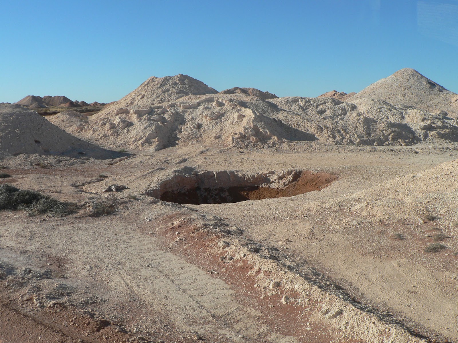
The guide was a German who came here in 1969 as a tourist and ended up as a miner for 35 years and he liked to talk about his own experience and stories in good English but a bad accent that was hard to understand. But we saw some really interesting sites: an underground dugout home, an underground mine with some traces of opal in the walls, the opal fields where he (and many others) worked, a field full of deep vertical shafts, open holes in the ground, and large piles of the dugout material, broken machinery... 
The abandoned mine field
I find it strange that they are not required to rehabilitate the area when it is abandoned, it is just left there open, no fencing just signs warning of the dangers. This is still the "wild west" in the middle of South Australia. 
That's what they are looking for: opal layers in the mine wall
The Breakaway Reserve
We were then taken out of town to the Breakaway Reserve, a low range of colourful exposed sandstone outcrops, once part of the Stuart Ranges. The forms and colours of these hills were similar to what we saw in the Death Valley in California a few years ago, a magnificent view. 
Colourful ranges (Breakaway Reserve) 

Then we passed the Moonplain, a flat rocky area where usually there is no vegetation at all but some little grass patches were there now. 

The dead camel (Breakaway Reserve)


On the way back we passed along a section of the Dingo Fence, a 5800 km long continuous fence built to protect South-East Australia from the dingos (not very successful...).

The facade of the Serbian Church
The last stop was the Serbian Underground Church, a recent work but traditional orthodox architecture and beautiful sandstone sculptures carved into the sandstone.


Inside the Serbian Orthodox Church


Our itinerary can be seen at the following Google Map:
http://g.co/maps/wcwv8 
(Note that to see the route after Bowen, you need to move down to the bottom of the left panel, and select the following pages!)


Múlt vasárnap indultunk el Whyalla-ból, Dél-Ausztrália déli tengerpartjáról, fölfelé a földrész közepe felé. Első állomásunk Coober Pedy volt, mintegy 600 km-el északabbra, már jól bent a sivatagos területen. Ez a kisváros az opál-bányászatról híres. A 19. szd. vége felé találtak itt opált, és a századforduló idején lendült fel a bányászat, és azóta is folyik, leginkább egészen kisipari módszerekkel, egyéni vagy pár fős kis-vállalkozásként. Úgy látszik annyi pénz nincs benne hogy nagyipari bányászatot vonzana. Még ma is bárki válthat egy engedélyt, és kijelölhet magának egy 50x100m-es területet ahol elkezdheti túrni a földet. Persze ma már gépesítve csinálják, de úgy is elég nehéz és kétséges munka. A város másik érdekessége az hogy sok lakóház a föld alá van építve, belevágva a nagyon könnyen alakítható, de szilárd, kréta-szerű mészkő sziklába. Ebben a klímában, ahol napközben még télen is 40 fok fölé megy a hőmérséklet (ötven fölöttit is mértek), éjszaka meg fagypont körül van, ez nagy előny, a földalatti helységekben állandó 18-20 fok van télen-nyáron. Még most is a földalatti lakások a legkelendőbbek, persze minden modern kényelemmel felszerelve. Itt töltöttük a hétfői napot, délelőtt körülnéztünk a város központjában, rengeteg fura figura megfordult itt, sok érdekes "műalkotás" "díszíti" a látképet. Délután meg elmentünk egy félnapos túrára. A vezető egy német származású pasas volt, aki 1969-ben jött ide mint turista, aztán ittragadt, 35 évig dolgozott mint bányász, úgyhogy sokat tudott a város történetéről meg az opálról, és nagyon szeretett mesélni. Sajnos olyan rossz kiejtéssel beszélt angolul, hogy a felét sem értettük annak amit mondott, de néha még az is sok volt... Persze nincsen szervezett túra bolt-látogatás nélkül, ahol másfél órát hallgattuk az előadását az opál különböző fajtáiról, minőségéről, mit érdemes venni, stb... aztán meg várhattuk amíg a csoportból néhányan befejezik a vásárlást és alkudozást... a végén már az idegeimre ment. De aztán végül láttunk néhány igazán érdekes helyet, voltunk egy földalatti lakásban, egy működő bányában, megmutatta a falban azt a kis vékony csíkocskát ahol az értékes követ lehet találni. Később kimentünk a városon kívülre a már felhagyott bányászati területre, ahol kisebb-nagyobb túrások, buckák és közöttük nyitott nagy lukak vannak ameddig a szem ellát, megmutatta a saját korábbi területeit és elmesélte hogy hol és mennyi hónapi kutatás után talált ennyit-meg-ennyit... Nekem furcsa, hogy manapság ezt még lehet, csak úgy otthagyni a kibányászott területet minden rehabilitáció, tereprendezés nélkül, be sincs kerítve csak éppen ki van téve egy tábla hogy veszélyes terület, tilos bemenni... Ez még mindig a "vadkelet" itt Dél-Ausztrália közepén.
Elmentünk egy kicsit messzebbre a Breakaway Reserve-hez, ez egy alacsony lepusztult domb/hegysor, érdekes, színes homokkő falaival a Death Valley-re emlékeztetett minket amit California-ban láttunk pár éve. Visszafelé a Dingo Fence mentén jöttünk, ez egy több mint 5000 km hosszú folyamatos kerítés amit a dingók (vadkutyák) terjedése ellen építettek a dél-keleti területek állattenyésztése védelmében. Végül voltunk egy földalatti szerb orthodox templomban, ami nem régen épült, érdekes modern szobrok díszítik a homokkő falba faragva, egy helyi művész alkotásai. 
Az útvonalunk a következo Google Map-on látható:
http://g.co/maps/wcwv8
(A Bowen utáni szakaszokhoz le kell menni a baloldali panel aljára, és a következo oldalakra kattintani!!)