(Magyar összefoglaló a végén)
 |
| A salt lake on the way to Coober Pedy |
Sunday, 2 Sep, Coober Pedy - We left Whyalla early and travelled all day, 600 km to North, along the Stuart Hwy. The landscape has changed often, sometimes dense bushland, then almost barren flat desert, and a few sparkling white salt lakes. One emu grazing near the road, and many kangaroo/wallaby carcasses on the road.
 |
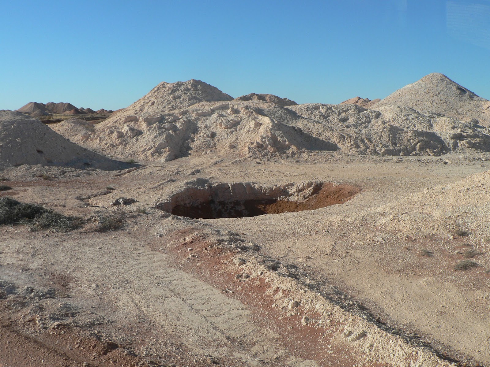
| Approaching the opal fields |
On the approach to the town we saw a lot of abandoned prospecting holes and dug up earth and a few larger scale mining sites as well. We arrived to Coober Pedy at 5 pm and booked into the Opal Inn caravan park. We had dinner in the inn restaurant for a change, with a glimpse of the social scenery, mostly other grey nomad couples like us, plus a few young miners having their evening meal.
 |
| The main street of Coober pedy |
Monday, 3 Sep, Coober Pedy - This morning we had a look around town. First walked down and up again along the main street, taking in all the "attractions": opal shop, opal shop and more opal shops... mixed with some essential services. But the surroundings and the scenery were interesting, lots of small hills with "dugout" homes in them.
 |
| The view of the town |
 |
| The Big Winch |
We went up to a lookout overlooking the town centre, it is quite a unique view, I can't say it's beautiful but certainly interesting. There is the Big Winch up there, representing one of the key tools of trade here. It is a replica of the original that was destroyed by a cyclone in 1986.
 |
| An old dugout home |
In the afternoon we went on a tour to learn more of this town and opal mining. It was a good tour apart from the fact that we had to spend about 1.5 hours in two different opal centres where we were told much more than we ever wanted to know about opal, its types, qualities, etc. to the minute detail, what to look for when buying, and then wait until some of the tour members finished their shopping.
 |
| A modern dugout |
The guide was a German who came here in 1969 as a tourist and ended up as a miner for 35 years and he liked to talk about his own experience and stories in good English but a bad accent that was hard to understand. But we saw some really interesting sites: an underground dugout home, an underground mine with some traces of opal in the walls, the opal fields where he (and many others) worked, a field full of deep vertical shafts, open holes in the ground, and large piles of the dugout material, broken machinery...
 |
| The abandoned mine field |
I find it strange that they are not required to rehabilitate the area when it is abandoned, it is just left there open, no fencing just signs warning of the dangers. This is still the "wild west" in the middle of South Australia.
 |
| That's what they are looking for: opal layers in the mine wall |
 |
| The Breakaway Reserve |
We were then taken out of town to the Breakaway Reserve, a low range of colourful exposed sandstone outcrops, once part of the Stuart Ranges. The forms and colours of these hills were similar to what we saw in the Death Valley in California a few years ago, a magnificent view.
 |
| Colourful ranges
(Breakaway Reserve) |
Then we passed the Moonplain, a flat rocky area where usually there is no vegetation at all but some little grass patches were there now.
 |
| The dead camel (Breakaway Reserve) |
On the way back we passed along a section of the Dingo Fence, a 5800 km long continuous fence built to protect South-East Australia from the dingos (not very successful...).
 |
| The facade of the Serbian Church |
The last stop was the Serbian Underground Church, a recent work but traditional orthodox architecture and beautiful sandstone sculptures carved into the sandstone.
 |
| Inside the Serbian Orthodox Church |
Our itinerary can be seen at the following Google Map:
http://g.co/maps/wcwv8
(Note that to see the route after Bowen, you need to move down to the bottom of the left panel, and select the following pages!)
Múlt vasárnap indultunk el Whyalla-ból, Dél-Ausztrália déli
tengerpartjáról, fölfelé a földrész közepe felé. Első állomásunk Coober
Pedy volt, mintegy 600 km-el északabbra, már jól bent a sivatagos
területen. Ez a kisváros az opál-bányászatról híres. A 19. szd. vége
felé találtak itt opált, és a századforduló idején lendült fel a
bányászat, és azóta is folyik, leginkább egészen kisipari módszerekkel,
egyéni vagy pár fős kis-vállalkozásként. Úgy látszik annyi pénz nincs
benne hogy nagyipari bányászatot vonzana. Még ma is bárki válthat egy
engedélyt, és kijelölhet magának egy 50x100m-es területet ahol
elkezdheti túrni a földet. Persze ma már gépesítve csinálják, de úgy is
elég nehéz és kétséges munka. A város másik érdekessége az hogy sok
lakóház a föld alá van építve, belevágva a nagyon könnyen alakítható, de
szilárd, kréta-szerű mészkő sziklába. Ebben a klímában, ahol napközben
még télen is 40 fok fölé megy a hőmérséklet (ötven fölöttit is mértek),
éjszaka meg fagypont körül van, ez nagy előny, a földalatti helységekben
állandó 18-20 fok van télen-nyáron. Még most is a földalatti lakások a
legkelendőbbek, persze minden modern kényelemmel felszerelve. Itt
töltöttük a hétfői napot, délelőtt körülnéztünk a város központjában,
rengeteg fura figura megfordult itt, sok érdekes "műalkotás" "díszíti" a
látképet. Délután meg elmentünk egy félnapos túrára. A vezető egy német
származású pasas volt, aki 1969-ben jött ide mint turista, aztán
ittragadt, 35 évig dolgozott mint bányász, úgyhogy sokat tudott a város
történetéről meg az opálról, és nagyon szeretett mesélni. Sajnos olyan
rossz kiejtéssel beszélt angolul, hogy a felét sem értettük annak amit
mondott, de néha még az is sok volt... Persze nincsen szervezett túra
bolt-látogatás nélkül, ahol másfél órát hallgattuk az előadását az opál
különböző fajtáiról, minőségéről, mit érdemes venni, stb... aztán meg
várhattuk amíg a csoportból néhányan befejezik a vásárlást és
alkudozást... a végén már az idegeimre ment. De aztán végül láttunk
néhány igazán érdekes helyet, voltunk egy földalatti lakásban, egy
működő bányában, megmutatta a falban azt a kis vékony csíkocskát ahol az
értékes követ lehet találni. Később kimentünk a városon kívülre a már
felhagyott bányászati területre, ahol kisebb-nagyobb túrások, buckák és
közöttük nyitott nagy lukak vannak ameddig a szem ellát, megmutatta a
saját korábbi területeit és elmesélte hogy hol és mennyi hónapi kutatás
után talált ennyit-meg-ennyit... Nekem furcsa, hogy manapság ezt még
lehet, csak úgy otthagyni a kibányászott területet minden rehabilitáció,
tereprendezés nélkül, be sincs kerítve csak éppen ki van téve egy tábla
hogy veszélyes terület, tilos bemenni... Ez még mindig a "vadkelet" itt
Dél-Ausztrália közepén.
Elmentünk egy kicsit messzebbre a Breakaway Reserve-hez, ez egy alacsony
lepusztult domb/hegysor, érdekes, színes homokkő falaival a Death
Valley-re emlékeztetett minket amit California-ban láttunk pár éve.
Visszafelé a Dingo Fence mentén jöttünk, ez egy több mint 5000 km hosszú
folyamatos kerítés amit a dingók (vadkutyák) terjedése ellen építettek a
dél-keleti területek állattenyésztése védelmében. Végül voltunk egy
földalatti szerb orthodox templomban, ami nem régen épült, érdekes
modern szobrok díszítik a homokkő falba faragva, egy helyi művész alkotásai.
Az útvonalunk a következo Google Map-on látható:
http://g.co/maps/wcwv8
(A Bowen utáni szakaszokhoz le kell menni a baloldali panel aljára, és a következo oldalakra kattintani!!)


No comments:
Post a Comment