(Magyar összefoglaló a végén)
 |
| Norseman town centre |
 |
| Wildflowers in Norseman |
 |
| The Nullarbor with trees and mirage above the road |
 |
| The Nullarbor as it should be |

 |
| The ruins of the old Telegraph station |
 |
| Flowers blooming on the Nullarbor |
 |
| The "true" Nullarbor |
 |
| The Bunda Cliffs |
 |
| The boardwalk at Head of Bight |
After lunch we left the van at the roadhouse, and went further East 14 kms, to the "Head of Bight" whale observatory. This is the Northernmost point of the Bight, where many Southern Right Whales congregate at this time of the year, mating and giving birth and waiting for their calves to grow and get storng enough for the journey back South to the Atlantic waters. Finally once on our trip we are at the right place at the right time.
 |
| Mother and calves |
 |
| A big tail |
... a group of dolphins circling around two females with calves, not sure if just for curiosity or for any more serious intent... We could not leave the observation platforms for more than 2 hours despite the strong cold wind blowing into our faces. The cliffs and the sand dunes further East gave a wonderful beckdrop to this fantastic show.
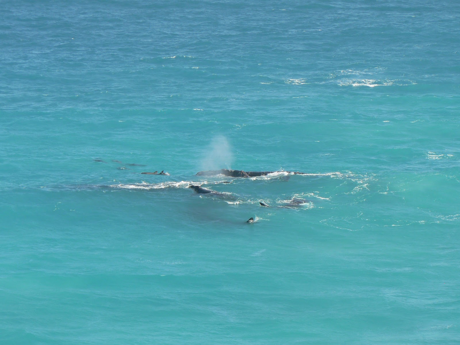 |
| Whales and dolphins |
Thursday, 30 Aug, Streaky Bay - Not much to report. Very cold, cloudy grey unfriendly day. Travelled from Nullarbor to Ceduna, passed the SA Quarantine inspection, then on to Streaky Bay, a small fishing village on the West side of the Eyre Peninsula. The caravan park is at the beach, but we did not benefit much from it in this cold, it was better to stay in the van.
 |
| Murphy's Haystacks |
The key attraction was Point Labatt, about 50 km further south, a lookout high on a cliff looking down on a secluded little beach where a colony of sea lions (similar to seals but a different species) live in peace.
 |
| Sea lions and birds at Point Labatt |

 |
| Spring flowers at the Eyre Peninsula |
Back in the camp in the afternoon we enjoyed a walk along the calm beachfront and the fresh flounder for dinner.
 |
| On the way to Whyalla we passed the half-way across the continent |
 |
| The steel works, Whyalla |
Tomorrow we are turning North again, starting the next phase of our journey: the Red Centre!
Our itinerary can be seen at the following Google Map:
http://g.co/maps/wcwv8
(Note that to see the route after Bowen, you need to move down to the bottom of the left panel, and select the following pages!)
Múlt vasárnap (aug 26) jobban éreztem magam, továbbindultunk Kalgoorlie-bol, de csak a legközelebbi településbe, Norseman-ba. Innen indul kelet felé a foút, itt még egyszer megpihentünk, kicsit vásároltunk, mivel mondták, hogy a következo 1500 km-en erre nem sok lehetoség lesz.
A hét elso felében áthaladtunk a Nullarbor síkságon. A név azt jelenti hogy fa nélküli, ez egy többszáz km-es tömör mészko fennsík, csak apró talajmenti növényzet marad meg rajta. Ennek ellenére elég sok olyan szakasz volt ahol suru bozótot, még magas fákat is láttunk, de voltak teljesen kopár, asztal-sima szakaszok is. Délelottönként utaztunk, déltájban letáboroztunk, délután pihentünk, és nézelodtünk ha volt mit. 2-300 km-enkánt vannak ún. roadhouse-ok, ahol tankolni lehet, meg enni, van motel és a lakókocsit is fel lehet állítani. Volt néhány érdekesség, pl a leghosszabb egyenes útszakasz (145 km). Szerda reggel átértünk Dél-Ausztrália államba, innentol az út egész közel halad a tengerparthoz, ahol 80-90 m magasból függoleges sziklafal szakad le a vízhez (Bunda Cliffs), nem egy barátságos part, de nagyon látványos, több kilátóponton is megcsodáltuk.
A legnagyobb látványosság a "Head of Bight" volt, egy tengerparti kilátópont, ahonnan bálnákat lehet megfigyelni. Ez a hely a Great Australian Bight (nagy lapos déli tengeröböl) északi csúcsánál van, az öböl legvédettebb és legmelegebb része, ahol minden évben júniustól októberig összegyulnek a bálnák, itt szülnek, itt nevelgetik a kicsinyeiket amíg eléggé megerosödnek hogy újra le tudnak menni délre az Antarktisz vizeire. Fantasztikus látvány volt, egész közel jöttek a parthoz, alig 10-20 m távolságból tudtuk figyelni oket ahogy úszkálnak, játszanak, a kicsik szopnak, vagy csak lebegnek a vízben. Vagy 2 órát nézelodtünk ott, legalább 2 tucat bálnát láttunk, alig tudtuk otthagyni, pedig jó hideg szél fújt, nem volt kellemes, bár sütött a nap. Nagy élmény volt, már nagyon régen vágytunk "bálna-lesre", próbáltuk is egy párszor, de nem sok sikerrel.
Csütörtökön értünk ki a Nullarbor síkságból az Eyre félszigetre és 2 napot Streaky Bay-ben töltöttünk, ez egy kis halászfalu a félsziget nyugati partján. A kemping egy csendes öböl partján volt, nagyon kellemes helyen, de többnyire olyan hideg volt, hogy nem sokat tudtunk kint tartózkodni. Pénteken elmentünk egy kis körútra a környéken, volt néhány érdekes látnivaló. Murphy's Haystacks: egy csomó érdekes formájú és színu szikla egy kis domb tetején, másfél-millárd éves lekopott gránit oszlopok, nagyon érdekes látványt nyújtanak, mintha emberkéz alkotta volna oket, Henry Moore-t juttatták eszünkbe. Point Labatt: egy kilátópont egy meredek sziklaorom tetején, ahonnan egy teljesen megközelíthetetlen kis homokos partszakaszra lehet lelátni, ahol egy "sea lion" (oroszlán-fóka magyarul, bár nem fóka igazán, más faj csak hasonló) kolónia él. Remekül meg lehetett figyelni oket onnan fölülrol ahogy henteregnek a homokban, játszanak, vagy csak hasalnak mintha nem is élnének. Jó sokáig elnézelodtünk, maga a környezet is nagyon szép volt a színes kövekkel és hullámokkal. Hazafelé még jópár szép kilátóponton megálltunk körülnézni, és sok színes vadvirágot is láttunk itt-ott, itt a tavasz (mégha hideg is van).
Ma, szombaton (szept. 1) továbbjöttünk a félsziget másik oldalára, Whyalla városkába, 370 km-re. A fo célunk egy Harvey Norman üzlet volt. Februárban vettem egy video kamerát Sydney-ben, és olyan 3-éves garanciát vele, hogy ha elromlik, kicserélik egy újra. Hát most elromlott, és reméltem, hogy itt ki tudom cseréltetni. Félig sikerült: beadtam a kamerát, de csak egy ígéretet kaptam, hogy a cserét utánam fogják küldeni, akárhol is leszek. Hát, úgy legyen...
Miután ezzel megvoltunk, kicsit körülnéztünk. Ez a kisváros a vasmure épült a 20. szd elején. A vasérc a közeli Iron Knob melletti bányákból jött, amik már nem muködnek, de a vasmu az muködik, nem tudom most honnan hozzák az ércet. Volt itt egy hajógyártó telep is a 2.VH idején, de a 70-es években bezárták. Van egy kiköto is, elég nagy városka, 22 ezer lakossal, nem tudm, mibol élnek, de elég élettelinek tunik. Van egy jó meredek domb a vízparton (Hammock Hill), szép kilátással a vasmure, kikötore és a városkára.
Holnap továbbindulunk észak felé, utunk következo szakasza az ország közepébe vezet, a Red Centre-be.
Az útvonalunk a következo Google Map-on látható:
http://g.co/maps/wcwv8
(A Bowen utáni szakaszokhoz le kell menni a baloldali panel aljára, és a következo oldalakra kattintani!!)
No comments:
Post a Comment