Sunday 3 July 2016

Mataranka and Borroloola


(Magyar változat a végén)


Mango plantation along the Arnhem Highway
Saturday 25 June we left Couzens Camp in the Mary River National Park, back to the Arnhem Highway, and returned to the Stuart Highway. We saw huge fruit tree plantations along the way, alternated with bushland and lots of termite mounds again.


The thermal pool at the Resort
We turned South on the Stuart Highway and after about 400 km we reached Mataranka. Mataranka is a small rural community, only a few hundred inhabitants. Its main tourist attraction is the thermal pools at several places with warm (34 degrees), crystal clear water bubbling up from underground springs. One of the pools is right at the Mataranka Homestead Resort, offering different kinds of accommodation, including a caravan park. We spent the next two nights here doing nothing much other than resting and enjoying the thermal pools.


Bitter Springs
A bit further back from the Homestead is another, bigger thermal pool called Bitter Springs. It was named by a worker on the Overland Telegraph Line in 1871, for the bitter taste and smell of the water. The smell is caused by bacteria that use the oxygen from the sulphate minerals in the water, leading a by-product of hydrogen sulphide, also known as rotten egg gas. Actually, the smell is not as bad as the name suggest, and the water is very pleasant. The water here flows in a half-circle loop of a few hundred metres where one can float with the current among the thick forest of tall Livistona palms and paperbark eucalypti. We both have done a few rounds with the current, walking back along the pool each time.
The palm forest around Bitter Springs

The area around the pools is a natural breeding ground of the little red flying fox. While they are protected species, they make a lot of damage in the palms, and nuisance to the tourists. At the Resort water sprinklers are installed at the level of the palm tops in an (not too successful) attempt to move them away from the walking tracks.

(We have been here in 2012)

Monday (27 June) morning we continued Southward on the Stuart Highway, then after about 160 kms we turned East on the Carpentaria Highway. This is mostly a one-lane road with very little traffic, going through a very sparsely populated area. If we meet a car in the opposite direction, both cars have to slow down and move aside on the wide gravel shoulder to let the other vehicle pass. Fortunately there is so little traffic, it only happens a few times along the way.


The Carpentaria Highway
Our destination was Borroloola, near the Gulf of Carpentaria, but it was too far for one day. We spent the night at a free camp site beside a creek called Little River. As most other waterways around here, it is not flowing during the dry season, but there was quite a large pool of water beside the camp and even saw a few water birds, hunting for their evening meal. We met a couple from Adelaide and had a good chat with them after dinner. It was a nice evening, much cooler than further North and fortunately free of any flying and biting insects.


Our camp site at Little River
Next morning (28 June) from here it was only another 130 kms to Borroloola. About 60 kms before Borrolooa we passed the huge McArthur River Mine where zinc, lead and silver are mined and transported to the port at Bing Bong at the Gulf of Carpentaria, 50 km passed Borroloola. From here on, the road becomes two-lanes and much better quality. 


The Police Station Museum
The township of Borroloola is located on the McArthur river. It was officially created in 1885, after the discovery of various metallic ores but mining ventures were mostly unsuccessful until the 1960s and the town never developed as a major centre. It works as a service and supply centre for the surrounding areas and for the tourists mostly coming here for fishing in the estuarine waters and in the Gulf. According to the tourist brochures "fishing up here is out of this world", but as we are not into fishing, we could not verify this.


A painting from the Art Centre
We spent two nights here, doing some shopping and looking at all the "attractions", of which there are not that many. The old Police Station, built in 1886, now restored as a museum, houses an impressive collection of tools, machinery and information displays about the history of the town. 

There is a local art centre showing and offering for sale (for exorbitant prices) a collection of Aboriginal art works.


The old and new  road across the McArthur River
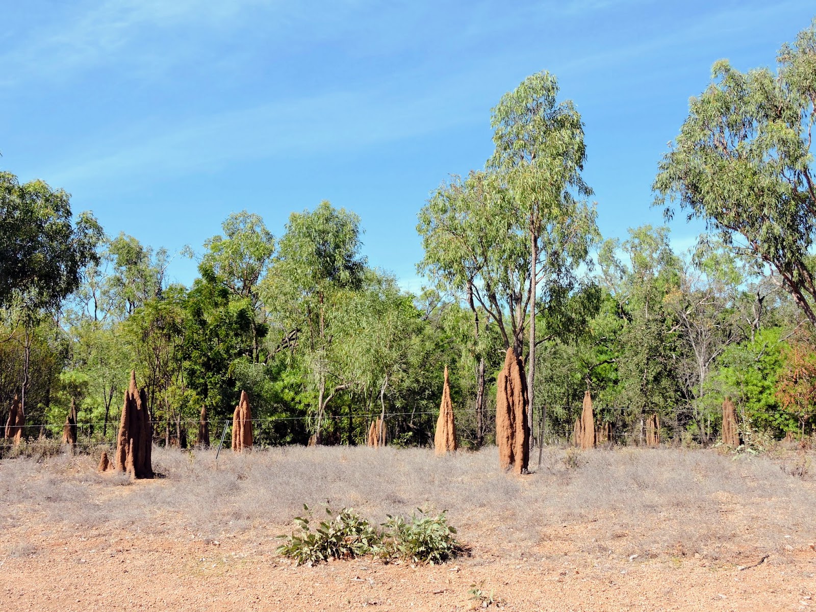
A bit further out of town we had a look at the McArthur river where the old crossing is beside the new bridge. This leads to the Savannah Way, an unsealed gravel road toward Queensland. Originally our plan was to continue along that road, this was the main reason we came here. But then, we changed our mind...


--------------------


Újabb termesz-várak
Szombaton, június 25-én indultunk tovább a Mary Riaver NP-ből, vissza az Arnhem Highway-re, majd onnan a Stuart Higway-re. Útközben sok gyümolcsfa-ültetvényt láttunk, bozótos területekkel váltakozva, tele itt is sok termesz-várral.


Bitter Springs
A Stuart Highway-n dél felé folytattuk az utat, és kb 400 km után értünk Mataranka-ba. Ez egy kis falusias település csak pár száz lakossal. A fő turista-csalogató a környékén található termálvizű fürdők, 34 fokos meleg kristálytiszta vízzel ami földalatti forrásokból tör föl. Az egyik ilyen fürdő a Mataranka Homestead Resort-ban van, ahol különféle szállás-lehetőségeket kínálnak, van egy kemping is. Itt töltöttük a következő két éjszakát. Első este mindjárt fürödtünk egy jót a közeli termálfürdőben.

Másnap visszamentünk a kicst távolabbi nagyon termál fürdőhöz, amit Bitter Springs-nek (keserű forrás) hívnak. Egy munkás nevezte el így 1871-ben mert a víz valóban kesernyés izű és szagú. A szagát a vízben lévő baktéria okozza, ami a vízben oldott szulfát sókból elvonja az oxigént, és kénhidrogén marad belőle. De valójában nem olyan rossz a szaga és a víz nagyon kellemes. Itt egy pár száz méter hosszú félkörben lehet lebegni a lassú árral a sűrű pálmaerdő közepén, amit többször is megtettünk.


Pálmaerdő a fürdő körül
A fürdő körüli pálmaerdő állandó lakóhelye egy denevér-fajtának (little red flying fox). Ezek védett állatok de elszaporodva nagy kárt tesznek a pálmaerdőben és sok kellemetlenséget okoznak a turistáknak. A Resort-ban magas oszlopokra erősített permetezővel prbálják korlátozni őket legalább a gyalogutak környékén, nem sok sikerrel.

(Jártunk itt 2012-ben is...)


Az egysávos autóút
Hétfőn, jun. 27.-én tovább indultunk dél felé a Stuart Highway-n, és kb 160 km után keletnek fordultunk a Carpentaria Highway-re. Ez legnagyobb részén egy egysávos út egy nagyon gyéren lakott terülten keresztül. Ha szembejön egy autó, mindkettőnek le kell húzódnia félig a széles padkára, csak így tudnak elhaladni egymás mellett. Szerencsére olyan kicsi a forgalom, ez ritkán fordul elő.


Az uticélunk Borroloola település volt a Carpentaria Öböl közelében, de ez túl messze volt, megálltunk éjszakára egy szabad táborhelyen egy kis patak mellett amit Little Creek-nek hívtak. mint a legtöbb folyóvíz ezen a vidéken, ez sem folyik a száraz évszakban, de itt megmaradt egy elég nagy vízmedence, még néhány vízimadarat is láttunk halászni. Találkoztunk egy Adelaide-i házaspárral akikkel jól elbeszélgettünk vacsora után. Kellemes este volt, jóval hűvösebb mint északabbra és szerencsére mentes minden csípkedő rovaroktól.

Másnap reggel (jun. 28) innen már csak 130 km volt Borroloola-ig. Kb 60 km-el B. előtt hagytuk el a hatalmas McArthur River Bányát, ahol cink-, ólom- és ezüst-kitermelés folyik, amit a Bing Bong nevű kikötőbe szállítanak a Carpentaria Öbölben, 50 km-re Borroloola-tól. Innen kezdve széles kétsávos jó állapotú út vezetett Borroloola-ba.


Táborhelyünk Borroloola-ban
Borroloola a McArthur folyó partján fekszik. Hivatalosan 1885-ben létesült, miután különféle fém érceket találtak a környéken, de a bánya-vállalkozások többnyire sikertelenek voltak egész az 1960-as évekig és a településből soha nem lett fontos központ. Ma a környező lakosság  valamint a főleg horgászni érkező turisták szolgáltató és ellátóhelye. Állítólag ez a világ egyik legjobb horgász-vidéke, de mivel mi nem horgászunk, ezt sem bizonyítani sem cáfolni nem tudjuk.


A művészeti központ

Két éjszakát töltöttünk itt, kicsit vásároltunk, és végigjártuk a "nevezetességeket", amiből nem sok van. A régi rendőrség épülete 1886-ban épült, ma felújítva a városi múzeum, tele mindenféle régi eszközökkel, és információs táblákkal amik bemutatját a város történetét.


A McArthur folyó a régi gázlóval
Van egy helyi múvészeti központ, ahol Aboriginal festményeket mutatnak be és árulnak (elképesztő árakért).


Kicsivel a városon kívül megnéztük a McArthur folyót a régi gázló és az új híd keresztezésénél. Ez az út vezet az ún. Savanah Way-re, egy többszáz km-es földútra Queensland felé. Eredetileg az volt a tervünk, hogy erre megyünk tovább, ezért jöttünk ide. De aztán meggondoltuk magunkat...


2 comments:

  1. Miért gondoltátok meg magatokat? Nehéz? Veszélyes? Lassú? Gyertek az M3 -on az kellemesebb, bár nincs ennyi látnivaló!;) Üdv Pufi

    ReplyDelete
  2. Miért gondoltátok meg magatokat? Nehéz? Veszélyes? Lassú? Gyertek az M3 -on az kellemesebb, bár nincs ennyi látnivaló!;) Üdv Pufi

    ReplyDelete