Saturday, 1 September 2012

The Nullarbor to SA


(Magyar összefoglaló a végén)

Norseman town centre
Sunday, 26 Aug, Norseman - I felt much better this morning, so we left Kalgoorlie and drove to Norseman, 200 km South. This is a little mining town, about 1000 population, and a mine just beside the town. We drove around the town, some nice old houses, and lots of bright wild flowers. Did a bit more shopping before we go on the Nullarbor tomorrow, then spent the afternoon resting in the caravan park.
Wildflowers in Norseman
The Nullarbor with trees and
mirage above the road
Monday/Tuesday, 27/28 Aug - We travelled through the Nullarbor Plain along the Eyre Highway. We did about 350 km in the morning each day, leaving early and setting up camp around lunchtime, then resting and looking around a bit in the afternoon. Monday night we spent at Caiguna Roadhouse, today we are at Eucla Motor Inn. 

The Nullarbor as it should be
The road was interesting, the vegetation frequently changing. I expected the Nullarbor to be completely treeless (as its name indicates), and there were indeed sections like that, but there were many sections with quite dense bush and even high trees. Some patches of colourful wildflowers. Very few animals alive, only two emus grazing along the roadside, but far too many dead kangaroos on and at the side of the road. 
One "highlight" was the longest stretch of straight road in Australia. 

The ruins of the old Telegraph station
Eucla is situated at the edge of the Hampton Tablelands looking down on the coastal plains and the Southern Ocean in the background, a nice location for our overnight stay. We drove down to see the ruins of the old Telegraph station built in 1877, now almost totally covered by the sand.
Flowers blooming on the Nullarbor
The "true" Nullarbor
Wednesday, 29 Aug, Nullarbor Roadhouse - Just after leaving Eucla we crossed over to South Australia and reached the "true" Nullarbor plain: there was not a tree in sight, just very small bush covering the landscape on both sides of the road. 

The Bunda Cliffs
The road runs here much closer to the coast, and there were 3 lookout stops where we could see the near vertical walls of Bunda Cliffs dropping into the ocean from 40 to 80 m height; very impressive sights.

The boardwalk at Head of Bight
We got to the Nullarbor Roadhouse quite early, but we had to move our clocks forward by 1.5 hours to SA time, which is a bit difficult to get used to. 

After lunch we left the van at the roadhouse, and went further East 14 kms, to the "Head of Bight" whale observatory. This is the Northernmost point of the Bight, where many Southern Right Whales congregate at this time of the year, mating and giving birth and waiting for their calves to grow and get storng enough for the journey back South to the Atlantic waters. Finally once on our trip we are at the right place at the right time. 

Mother and calves
There were about a dozen or more whales, mostly mothers with their calves, very close to the shore, we watched them playing, turning round and around, mothers on their back upside down and the babies suckling, 
A big tail


... a group of dolphins circling around two females with calves, not sure if just for curiosity or for any more serious intent... We could not leave the observation platforms for more than 2 hours despite the strong cold wind blowing into our faces. The cliffs and the sand dunes further East gave a wonderful beckdrop to this fantastic show.
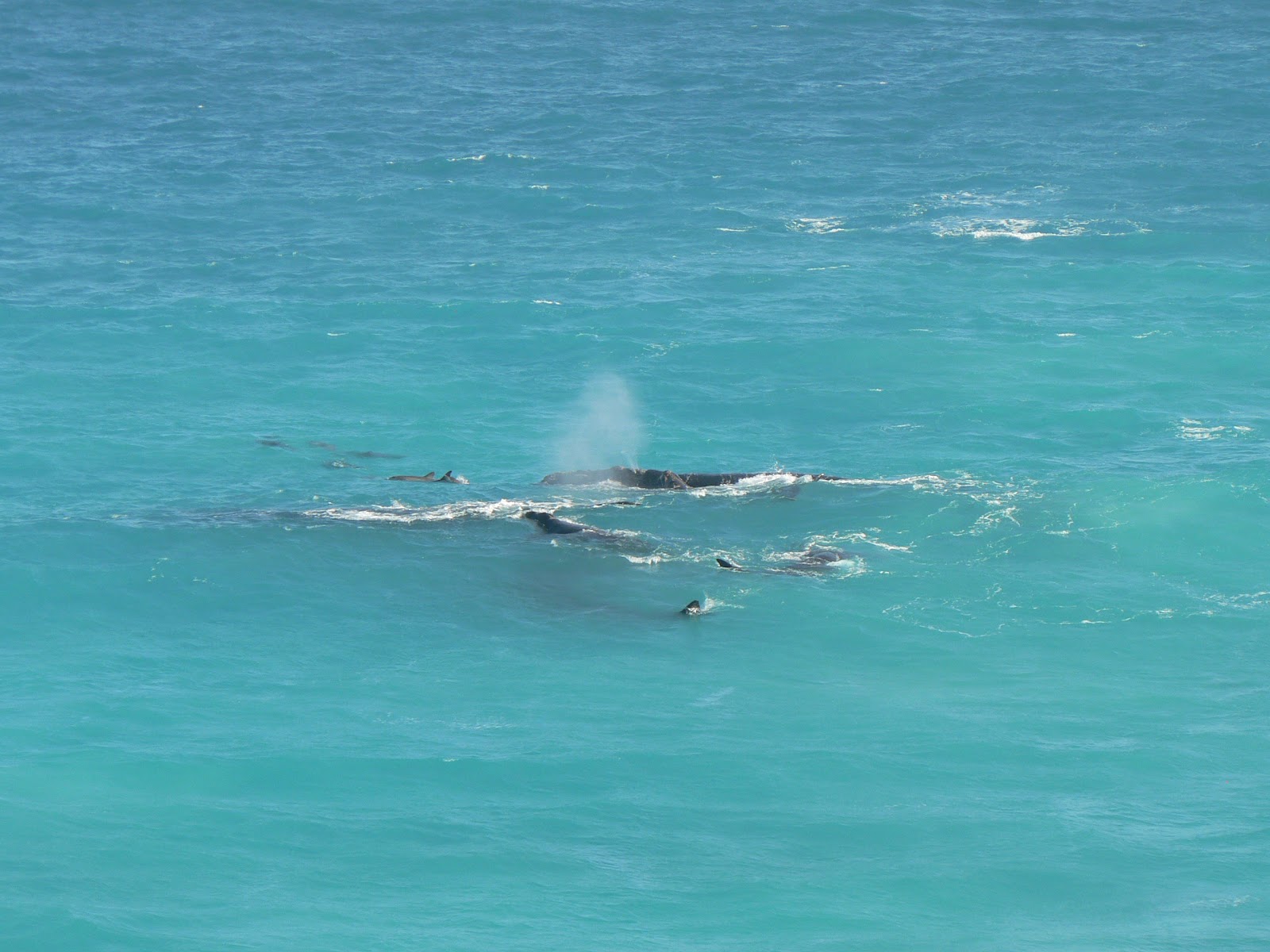
Whales and dolphins


Thursday, 30 Aug, Streaky Bay - Not much to report. Very cold, cloudy grey unfriendly day. Travelled from Nullarbor to Ceduna, passed the SA Quarantine inspection, then on to Streaky Bay, a small fishing village on the West side of the Eyre Peninsula. The caravan park is at the beach, but we did not benefit much from it in this cold, it was better to stay in the van.

Murphy's Haystacks
Friday, 31 Aug, Streaky Bay - This is such a pretty quiet place we decided to stay here for the day. We bought a freshly caught flounder at the seafood shop in town, then went for a round trip to see the local attractions. Murphy's Haystacks is a bunch of "inselbergs", 1.5 billion year old granite pillars and boulders at the top of a little hill, an amazing sight.

The key attraction was Point Labatt, about 50 km further south, a lookout high on a cliff looking down on a secluded little beach where a colony of sea lions (similar to seals but a different species) live in peace. 
Sea lions and birds at Point Labatt
From the viewing platform we could observe as they play and frolick at the shoreline, pups suckling or mostly just lay in the sand and on the rocks doing nothing; some looked doubtful to be alive, but then they moved. There were more than 50 animals on the beach and rocks, and lots of seabirds as well. The colours of the rock and the sea were also beautiful.

Spring flowers at the Eyre Peninsula
On the way back we made a detour on a coastal scenic route with pretty views of the high cliffs, the Granites beach, a popular surfing spot, and the snow-white sandhills around Yanerbie.
Back in the camp in the afternoon we enjoyed a walk along the calm beachfront and the fresh flounder for dinner.

On the way to Whyalla we passed
the half-way across the continent
Saturday, 1 Sep, Whyalla - This town is on the other side of the Eyre Peninsula, facing the Spencer Gulf, 370 km from Streaky Bay. We came here because there is a Harvey Norman store here. In February in Sydney I bought a video camera with replacement warranty, and it stopped working. I was hoping to get a replacement here; I was half successful: they took away my camera, but I only got a promise that they will send the replacement after me wherever I am. We'll see... 
The steel works, Whyalla
Apart from that, Whyalla is an old town based on the steel industry, the iron ore coming from the mines around the Iron Knob, 50 km further NW. There is a steel works which still seems to be operating, although the mines at Iron Knob are not, but there are other mines in the area. There was also a ship building yard, important in WW2 but closed in the 70s. There is a good view of the steel works, the port and the township from the Hammock Hill lookout.

Tomorrow we are turning North again, starting the next phase of our journey: the Red Centre!

Our itinerary can be seen at the following Google Map:
http://g.co/maps/wcwv8 
(Note that to see the route after Bowen, you need to move down to the bottom of the left panel, and select the following pages!)

Múlt vasárnap (aug 26) jobban éreztem magam, továbbindultunk Kalgoorlie-bol, de csak a legközelebbi településbe, Norseman-ba. Innen indul kelet felé a foút, itt még egyszer megpihentünk, kicsit vásároltunk, mivel mondták, hogy a következo 1500 km-en erre nem sok lehetoség lesz.
A hét elso felében áthaladtunk a Nullarbor síkságon. A név azt jelenti hogy fa nélküli, ez egy többszáz km-es tömör mészko fennsík, csak apró talajmenti növényzet marad meg rajta. Ennek ellenére elég sok olyan szakasz volt ahol suru bozótot, még magas fákat is láttunk, de voltak teljesen kopár, asztal-sima szakaszok is. Délelottönként utaztunk, déltájban letáboroztunk, délután pihentünk, és nézelodtünk ha volt mit. 2-300 km-enkánt vannak ún. roadhouse-ok, ahol tankolni lehet, meg enni, van motel és a lakókocsit is fel lehet állítani. Volt néhány érdekesség, pl a leghosszabb egyenes útszakasz (145 km). Szerda reggel átértünk Dél-Ausztrália államba, innentol az út egész közel halad a tengerparthoz, ahol 80-90 m magasból függoleges sziklafal szakad le a vízhez (Bunda Cliffs), nem egy barátságos part, de nagyon látványos, több kilátóponton is megcsodáltuk.
A legnagyobb látványosság a "Head of Bight" volt, egy tengerparti kilátópont, ahonnan bálnákat lehet megfigyelni. Ez a hely a Great Australian Bight (nagy lapos déli tengeröböl) északi csúcsánál van, az öböl legvédettebb és legmelegebb része, ahol minden évben júniustól októberig összegyulnek a bálnák, itt szülnek, itt nevelgetik a kicsinyeiket amíg eléggé megerosödnek hogy újra le tudnak menni délre az Antarktisz vizeire. Fantasztikus látvány volt, egész közel jöttek a parthoz, alig 10-20 m távolságból tudtuk figyelni oket ahogy úszkálnak, játszanak, a kicsik szopnak, vagy csak lebegnek a vízben. Vagy 2 órát nézelodtünk ott, legalább 2 tucat bálnát láttunk, alig tudtuk otthagyni, pedig jó hideg szél fújt, nem volt kellemes, bár sütött a nap. Nagy élmény volt, már nagyon régen vágytunk "bálna-lesre", próbáltuk is egy párszor, de nem sok sikerrel.
Csütörtökön értünk ki a Nullarbor síkságból az Eyre félszigetre és 2 napot Streaky Bay-ben töltöttünk, ez egy kis halászfalu a félsziget nyugati partján. A kemping egy csendes öböl partján volt, nagyon kellemes helyen, de többnyire olyan hideg volt, hogy nem sokat tudtunk kint tartózkodni. Pénteken elmentünk egy kis körútra a környéken, volt néhány érdekes látnivaló. Murphy's Haystacks: egy csomó érdekes formájú és színu szikla egy kis domb tetején, másfél-millárd éves lekopott gránit oszlopok, nagyon érdekes látványt nyújtanak, mintha emberkéz alkotta volna oket, Henry Moore-t juttatták eszünkbe. Point Labatt: egy kilátópont egy meredek sziklaorom tetején, ahonnan egy teljesen megközelíthetetlen kis homokos partszakaszra lehet lelátni, ahol egy "sea lion" (oroszlán-fóka magyarul, bár nem fóka igazán, más faj csak hasonló) kolónia él. Remekül meg lehetett figyelni oket onnan fölülrol ahogy henteregnek a homokban, játszanak, vagy csak hasalnak mintha nem is élnének. Jó sokáig elnézelodtünk, maga a környezet is nagyon szép volt a színes kövekkel és hullámokkal. Hazafelé még jópár szép kilátóponton megálltunk körülnézni, és sok színes vadvirágot is láttunk itt-ott, itt a tavasz (mégha hideg is van).
Ma, szombaton (szept. 1) továbbjöttünk a félsziget másik oldalára, Whyalla városkába, 370 km-re. A fo célunk egy Harvey Norman üzlet volt. Februárban vettem egy video kamerát Sydney-ben, és olyan 3-éves garanciát vele, hogy ha elromlik, kicserélik egy újra. Hát most elromlott, és reméltem, hogy itt ki tudom cseréltetni. Félig sikerült: beadtam a kamerát, de csak egy ígéretet kaptam, hogy a cserét utánam fogják küldeni, akárhol is leszek. Hát, úgy legyen...
Miután ezzel megvoltunk, kicsit körülnéztünk. Ez a kisváros a vasmure épült a 20. szd elején. A vasérc a közeli Iron Knob melletti bányákból jött, amik már nem muködnek, de a vasmu az muködik, nem tudom most honnan hozzák az ércet. Volt itt egy hajógyártó telep is a 2.VH idején, de a 70-es években bezárták. Van egy kiköto is, elég nagy városka, 22 ezer lakossal, nem tudm, mibol élnek, de elég élettelinek tunik. Van egy jó meredek domb a vízparton (Hammock Hill), szép kilátással a vasmure, kikötore és a városkára. 
Holnap továbbindulunk észak felé, utunk következo szakasza az ország közepébe vezet, a Red Centre-be.

Az útvonalunk a következo Google Map-on látható:
http://g.co/maps/wcwv8
(A Bowen utáni szakaszokhoz le kell menni a baloldali panel aljára, és a következo oldalakra kattintani!!)

Saturday, 25 August 2012

Albany to Kalgoorlie


(Magyar összefoglaló a végén)

Saturday, 18 Aug, Denmark - After a very cold night (6 degrees in the van) we woke up to a clear sunny day. Marty went back to Perth by bus and train, tomorrow he will fly back to Hobart. It was good to travel with him for a week. We came back to the camp and decided to stay here for today, to have a rest and enjoy a sunny day. 

Sunday, 19 Aug, Denmark - Another day of rest in Denmark, nothing to report.

King George Sound from the ANZAC memorial
Monday, 20 Aug, Albany - We came here in the morning, only about 50 km from Denmark, and spent the day sight-seeing. In the morning we went to Emu Point to see Oyster Harbour, then Middleton Beach, up to Mt.Adelaide to visit the ANZAC memorial and the views from the lookout to the outer bay (King George Sound) and the inner bay (Princess Royal Harbour), the Port and the town centre. 
Albany town centre
Then we had a walk around the town centre and a visit to St Johns Anglican Church. 

The Gap
In the afternoon we went to Torndirrup National Park, and saw the interesting features of the rocky ocean coast: the Gap and the Natural Bridge, the Blowholes, although it only blew wind today, but the sound of it was scary enough. The whole coastal landscape and vegetation was very impressive, even in this very cold and dark gray cloudy weather. On the way back we stopped at Frenchman Bay and at the Vancouver Peninsula for more pretty views of the bay and harbour. 
The Natural Bridge

Wave Rock
Tuesday, 21 Aug, Wave Rock resort, Hyden - We left the Southern coast, travelled about 350 km North to Hyden in miserable weather, strong winds and intermittent rain spells. The Wave rock is a few km-s from Hyden. There is a resort and caravan park nearby. The rain has stopped by the time we got here, or rather, it seems it has not rained here at all. The air was much warmer than in Albany, around 17-19 degrees, it is surprising how much difference a few hunder kms make. After lunch we walked around the rock and the other strange formations, boulders, hollows, etc. 

At the top of Wave Rock
We climbed up to the top of the Wave Rock, it is a huge monolith, and the views of the surrounding landscape were just as interesting, as well as the clouds racing through the sky in the very strong wind.

Hippo's Yawn
Local art in Hyden
In the wheat belt
Wednesday, 22 Aug, Kalgoorlie - Today we travelled most of the day from Wave Rock to Kalgoorlie, almost 500 km. We passed through Merredin, the centre of the wheat-belt, among beautifully cultivated yellow (canola) and green (wheat?) fields. The weather was sunny but cool, very strong winds. The landscape has changed after Southern Cross, thick bush and Salmon gums. 

Kalgoorlie main street
We arrived in Kalgoorlie around 3.30 pm, and found a place in the 4th caravan park - the first 3 were full, a big surprise after the almost empty parks we saw since we left Perth. We went for a walk in the town centre, along the old main street, aligned with lots of old historic buildings from the turn of the 20th century.

The Exchange Hotel
The Super Pit
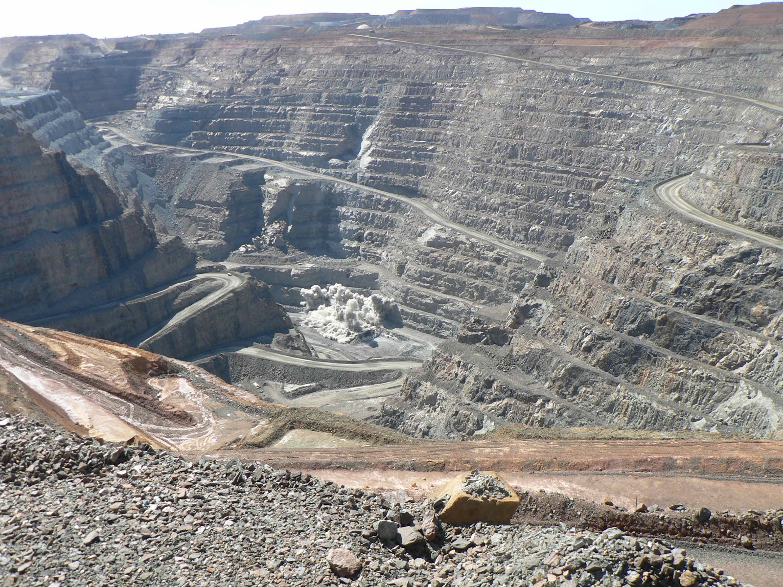
Thursday, 23 Aug, Kalgoorlie - I've got a sore throat, had a very bad night, could not sleep because of the coughing. Stayed in the van in the morning. In the afternoon we went for a little tour of the town, drove through the main street of Boulder, originally a separate little mining village, now merged with Kalgoorlie. Then we drove up to the Super Pit lookout and marvelled on the huge hole and the little toy machines and trucks working down there. Next, the Mt Charlotte Lookout, with views of Kalgoorlie town centre and all around, plus the reservoir where the water coming from the Perth Hills, 600 km from here, is stored. An amazing engineering feat in 1903.
Can you find this tiny car on the previous photo?

Hand-made bush bicycle
Friday, 24 Aug, Kalgoorlie - I am still not any better than yesterday but with the help of flu tablets I went out with Kate to see something from this town. In the morning we visited the Museum, a collection of stories, photographs, artefacts and a few recosntructed old buildings presenting the history of the town. 

Questa Casa. There was a girl behind each pink door.
After lunch we went on a tour of Questa Casa, the "oldest working brothel remaining from the gold rush era". The madam told us her story of how she bought the business 20 years ago coming from Queensland and having no experience whatsoever in this field, the story of how the brothel operated in the old times, and some funny stories about the girls and clients. We also saw the inside of the premises, the rooms, the decorations, etc. It was an interesting insight into a strange world.

Interior decoration in the reception room
The blast
Saturday, 25 Aug, Kalgoorlie - We planned to leave this place today, but I felt so sick this morning that we stayed. I slept in the van almost all day. Now I feel a bit better but still very weak. Hope I will get better by tomorrow. Kate went out to the Super Pit lookout to see a blast down in the pit at 1 pm. 

Our itinerary can be seen at the following Google Map:
http://g.co/maps/wcwv8 
(Note that to see the route after Bowen, you need to move down to the bottom of the left panel, and select the following pages!)

A múlt hétvégét Denmark-ban töltöttük, jó volt kicsit pihenni abban a nagyon kellemes, szép fekvésu kempingben. Hétfon továbbmentünk a déli part mentén Albany-ba. Ez csak 50 km-re van, korán odaértünk, aztán egész nap nézeldotünk a városban és környékén. Itt van egy nagyon nagy és biztonságos védett tengeröböl és belso kiköto, ez adta a hely fontosságát kezdettol fogva. A város a belso öböl belso partján kisebb dombok között van, szép fekvésu. Végigjártuk a belso öböl tengerparti strandjait, kilátó pontokat, emlékmuveket (innen hajózták be a legtöbb katonát a két világháború során), aztán sétáltunk a városközpontban, nagyon szépen rendbe van hozva, sok régi épület, és egy vadi új szupermodern szórakoztató központ a parton. Délután meg a külso öböl mentén jártuk végig a látnivalókat, az ódeán partja tele van fantasztikus szikla-formációkkal, szuk mély üregek, egy természetes szikla-híd, "blowhole", ami most csak ijeszto morgást és néha egy kis párát fújt, mert túl nyugodt volt a tenger. Az egész part fennséges és ijeszto, nagyon régi kozetek, valamikor egyben volt az Antarktisszal. Sajnos az ido nem a legjobb volt, többnyire felhos és nagyon hideg, napközben sem ment 12-13 fölé, és eros szél. De azért élveztük, csak a következményét nem...
Másnap (kedd, aug. 21) felkanyarodtunk észak felé, kb 350 km-t, Hyden-be. Itt is egy érdekes szikla-forma a látnivaló, a Wave Rock, egy hullám formájú szikla. Útközben elég pocsék ido volt, hol esett hol zuhogott, és nagyon eros szél fújt, de mire odaértünk, elállt az eso - pontosabban azt mondták hogy ott nem is esett, ez már az "outback" széle, odáig ritkán ér fel az esofront. Letáboroztunk a szikla melletti kempingben, és délután körbesétáltuk a látnivalókat. Ez a Wave rock egydarab hatalmas gránitszikla, kb 2.8 milliárd éves, a felszín alatt alakult ki ilyen formára, és "csak" pár millió évvel ezelott került a felszínre. Végigmentünk a hullám alján, felmásztunk a tetejére, onnan lehet csak látni, hogy milyen hatalmas, és a környezo táj is szép és érdekes. Van még több fura szikla-forma a környéken és egy pár másik ilyen nagy sziklatömb, de azokhoz nem mentünk el. Itt nem volt olyan hideg, 17-18 fok, de orkán-szeru szél, majd lefújt a szikla tetejérol, jól kapaszkodtunk egymásba. Sajnos délután már kezdtem érezni hogy valami nincs rendjén, fáj a torkom és ebbol baj lesz.
Szerdán továbbjöttünk észak-kelet felé Kalgoorlie-be, ez az aranybányászat központja. Útközben is szép tájakat láttunk, a fo búzatermelo vidéket kereszteztük, szép zöld és sárga (repce) földeket. 500 km-es út volt, délután 4 felé értünk ide, és meglepetésünkre csak a negyedik kempingben kaptunk helyet, de fo hogy kaptunk. Délután még sétáltunk egyet a városküzpontban a régi foutcán. A 19. szd. végén kezdodött itt az aranyláz, a tize évekre nagyon gazdag kisvárossá notte ki magát, sok szép régi (már itteni léptékben régi) épület most is megvan, szépen felújítva. Éjszaka nemigen tudtam aludni, egyfolytában köhögtem, csüt. délelott nem volt kedves sehova se menni. Délután azért elmentünk egy kicsit, végigautóztunk a K.-val összenott másik régi kis bányászvároska, Boulder, foutcáján, ott is van sok szép épület. Aztán felmentünk a "Super Pit" kilátóhoz. Ez egy óriási nyíltszíni fejtés, a luk 3.8 km hosszú 1.5 km széles és 500 m mély lesz 2021-ben amikor kimerül, addig évente 28 tonna aranyat termel, 550 ember dolgozik benne. Érdekes látvány belenézni, ahogy a kétemelet-magasságú óriás dömperek sziklával megrakva araszolnak felfelé a rámpán, mint pici hangyák. Fantasztikus mérnöki teljesítmény az egész. Aztán átmentünk a szomszédos Mt. Charlotte hegyre ahol a víztározó van, amibe Perth mellol, 600 km távolságból nyomják a vizet felszíni csovezetékben, 1903-ban nyílt meg - ez sem semmi!
Pénteken sem lettem sokkal jobban, de azért elmentünk kicsit nézelodni. Délelott megnéztük a múzeumot, sok régi történet, fénykép, használati tárgyak és magyarázatok a város és az aranybányászat történetérol, néhány régi felújított épület. Délután meg egy "nyilvánosház túrán" voltunk. Questa Casa egy ma is múködo nyilvánosház, ami még az aranyláz elején épült az egyetlen megmaradt a valamikori 13-ból. A "madam" elmesélte a saját történetét, hogy vette meg az üzletet húsz évvel ezelott Queensland-ból érkezve és minden ilyen irányú tapasztalat nélkül, ügyes üzletasszony lehet, meg a ház történetét, hogy muködött a régi szép idokben, milyen szigorú szabályok szerint, de milyen elonyös volt a lányoknak is meg a klienseknek is. 11 lány dolgozott itt régen, ma már csak ketto, elmúltak a régi szép idok. De jól kitalálta magának ezt a kis külön üzletet a túra-látogatással egész szép mellékkeresetre tehet szert. Megnéztük a szobákat is ahol az akció történik, a dekorációt, elég sok minden eredeti még. Sajnos a lányokat nem nézhettük meg :)) Érdekes, furcsa világ, ilyet még nem láttunk.
Ma, szombaton tovább akartunk menni, de olyan pocsékul éreztem magam reggel hogy inkább ittmaradtunk. Nem csak a flu, de közben a derekamba is jött egy lumbágó-szeru fájdalom, nehezen tudok mozogni. Feködtem és aludtam majdnem egész nap. Most egy kicsit jobban vagyok, remélem holnapra még jobb lesz. Kati közben elment mégegyszer a Super Pit kilátóhoz, mert 1-kor volt egy robbantás, azt meg lehetett nézni onnan.

Az útvonalunk a következo Google Map-on látható:
http://g.co/maps/wcwv8
(A Bowen utáni szakaszokhoz le kell menni a baloldali panel aljára, és a következo oldalakra kattintani!!)

Saturday, 18 August 2012

The South-West corner


(Magyar összefoglaló a végén)

Saturday, 11 Aug, Busselton - On Friday afternoon we picked up Marty after he finished work at CSIRO, and went to a close-by restaurant where we met Agnes (Gedeon), his colleague and we had a good long chat over drinks and dinner, mixed in Hungarian and English. It was a nice evening.
The Busselton Jetty
Saturday morning I finished and uploaded the next blog, then we packed up the van and left Perth. We drove South on the freeway, and by lunchtime we were at Bunbury. We drove around the town and stopped for lunch at the West coast. Then we continued down to Busselton, only 60 km further South-West, passing through a beautiful tuart forest. We set up in a caravan park, and drove in the town to look around. Busselton's main attraction is the jetty, almost 2 km long, with an underwater observatory at the outer end. Unfortunately the observatory was not open due to the murky water caused by strong winds on the previous days. We walked out to the end of the jetty and back, passing many fishermen. The sky was covered with thick clouds but the air was mild in the dead calm. Rain is coming by tomorrow.

Cape Naturaliste
Sunday, 12 Aug, Busselton - It was raining all night and morning, but the forecast predicted a dry gap after 10 am. So around 10 we jumped in the car and went to Cape Naturaliste at the West end of Geographe Bay. It was still raining on the way but it stopped when we got to Meellup Beach where we also stopped to look around. Then went up to the lighthouse at the cape and walked down to the Whales lookout, the point where whales can often be seen from September to November - unfortunately not the right time for us. We did not see whales, but the coastal vegetation, a few big kangaroos and the wind-swept see were worth the visit. 
Where are the whales?...
Unfortunately on our way back it started to rain heavily again and by the time we got back to the car, all our clothes and shoes were dripping wet. So we came back to the camp and spent the afternoon relaxing and trying to dry our clothes in the van. The forecast is showing more rain and very strong winds for this South-West corner of the state, it seems we are at the wrong place at the wrong time...


Lake Cave
Monday, 13 Aug, Augusta - The weather was much better today, partly cloudy but mostly sunny, cool but not much wind and only a few short showers. We packed up the van and came down South along the Caves Road with a detour to the beach at Gracetown. We passed many wineries but it was too early for tasting. We stopped at Lake Cave for a tour of the cave, an amazing place. 
Stalactites in Lake Cave
Voyager Estate
After the tour we had lunch, then turned back towards Margaret River looking for wineries. We visited 3 of those, Redgate, Voyager and Leeuwin Estates, tasted some wines and bought a few bottles. Redgate looked like a small family business, Voyager on the other hand is a high class affair, manicured gardens like in a French castle. 

Leeuwin Estate
Leeuwin is closer to our liking, more an English-style garden but also beautiful vegatation. We passed through the town of Margaret River and stopped to check out the river, then drove down to Augusta at the Southern end of the region.  

Whale watching
Tuesday, 14 Aug, Augusta - This morning finally, after a few unsuccessful attempts earlier, we went whale watching, a birthday present for the two of us from Marty! A 2.5 hour boat tour in Flinders Bay, South of Augusta, where whales used to stop and rest on their migration to their breeding ground up North along the Kimberley coast. 


There she is! (Marty's photo)
August is the very end of the Northbound migration, so there were not that many as before, but we still saw several whales, as much as can be seen from them, mostly the air blows, and a bit from their back. There was a mother and calf that we followed for a while they were very close to the boat. Also, there was one breeching behind the boat that many people saw, including Marty but both Kate and I missed it. It is very hard to get a glimpse of these movements, the whales usually stay on the surface for no more than 2-3 seconds. It is even harder to take photos or videos of them, for the same reason. 
Whale breaching (Marty's photo)
The ones included here for illustration are courtesy of Marty, who has better equipment and reflexes or maybe he is simply a better photographer than we are... The weather was not ideal but bearable, there were a few heavy showers and strong wind all the time, but in between there was a bit of sunshine as well. We saw a few birds too, ganets and albatroses, and seals on the rocks, we enjoyed the tour very much, thanks Marty!


Seals
Cape Leeuwin lighthouse
In the afternoon we went to Cape Leeuwin, the South-West corner of the continent, where the Indian Ocean meets the Southern Ocean. We visited the old lighthouse from 1895, still operating, one of the tallest in Australia at 35 m, and walked around the various lookout points with beautiful views of the windswept oceans and information displays about the lighthouse, shipwrecks and marine life. 
Cape Leeuwin
The Bicentennial Karri Tree
Wednesday, 15 Aug, Pemberton - We drove directly to Pemberton in the morning and set up the van in a caravan park, packed some food for lunch then went to discover the adjacent Warren National Park. It is home to a huge karri forest along the valley of the Warren River. 
The karri is a type of eucalyptus that grows up to 90 m high, the tallest tree in Australia. 
Marty going up
A few of these giants have been pegged and people can climb up to their top. Originally these were used as fire lookouts, now they are open to the public. The tallest of these is the Dave Evans Bicentannial Tree, with a top lookout height of 75 m. 
Marty at the top
We visited this tree and Marty climbed up to the top, we only watched from below. 

In the karri forest
We did a short walk in the karri forest from the tree to a lookout to see the Warren river valley and back. We had our picnic lunch at the tree, and later went to see Beedelup Falls. 

A tingle tree
Thursday, 16 Aug, Walpole - This morning we travelled another 120 kms South-East, and by 11 am we were set up in a caravan park at the beach near Walpole. Then we went on a tour of the attractions in this region, which is famous for its giant trees, this time tingle trees, which only grow in this area. They are huge trees, not as high as the karris, but their trunk is more voluminous, the girth at ground level may be more than 20 m. 
"The Giant" Tingle
We went up to a Hilltop lookout above the town, then we stopped at "the Giant Tingle Tree", said to be the largest of them all, with a girth of 24 m. 


Tree-top walk
We had our lunch and coffee in this picnic area, then drove further to the "Valley of the Giants", a national park with a tingle forest, where we did the tree-top walk, a 600 m long elevated walkway at 40 m above ground, among these magnificent trees. The vegetation below, around and above us was very pretty indeed and the steel structure of the walkway was also interesting, nicely done. Unfortunately the weather was far from perfect, very gray thick cloud cover, but at least it was not raining (just a little...). 

On the way home we went on a scenic drive around the region, beautiful green pastures, lots of cattle and sheep, vineyards, a bit like in the Southern Alps in Europe.

Denmark river
Denmark
Friday, 17 Aug, Denmark - Not to be confused with the European country, Denmark is a very pretty small town, named after the river of the same name, which, in turn, was named by one of the early settlers in the area in 1829. We came here this morning and had a similar program as yesterday: set up camp, then go on a discovery tour of the region. 
Marty testing the water in Greens Pool
We saw some beautiful beaches, Greens Pool, a secluded little bay with crystal clear calm water, Elephant Rocks, Waterfall Beach where we had our picnic lunch and coffee. 
Elephant rocks
The hillside behind Denmark
In the afternoon we drove around the hillsides behind the town, more green fields and cattle and sheep, nice views of the Wilson Inlet and the ocean, and some wineries. 

Ocean Beach
On the way home we stopped at Ocean Beach, at the mouth of Wilson Inlet for another pretty view of the coastal scenery. In the evening at home we celebrated my birthday with a bottle of sparkling red.

Wilson Inlet, Denmark
Saturday, 18 Aug, Denmark - After a very cold night (6 degrees in the van) we woke up to a clear sunny day. Marty went back to Perth by bus and train, tomorrow he will fly back to Hobart. It was good to travel with him for a week. We came back to the camp and decided to stay here for today, to have a rest and enjoy a sunny day. 

Our itinerary can be seen at the following Google Map:
http://g.co/maps/wcwv8 
(Note that to see the route after Bowen, you need to move down to the bottom of the left panel, and select the following pages!)

Péntek (aug 10) délután felvettük Marcit, és elmentünk vacsorázni egy étterembe egy itt élo magyar származású kolléganojével. Ágnes (Gedeon) gyerekkora óta küldföldön élt több országban, a mi gyerekeinkhez hasonló múlttal, de elég jól beszél magyarul is. Jól elbeszélgettünk, kellemes este volt.
Szombaton reggel felpakoltunk, és Marcival együtt elindultunk a tengerpart mentén tovább dél felé. Az elmúlt héten végigutaztuk Nyugat Ausztrália dél-nyugati csücskét. Sajnos az ido nem volt a legjobb, sokat esett, szeles, huvös többnyire elég kellemetlen volt, de azért megnéztük amit tudtunk. Busselton-ban végigsétáltunk a majd 2 km hosszú mólón, a kinti végén van egy vízalatti megfigyelo terem ami sajnos zárva volt a rossz ido miatt zavaros volt a víz. Másnap majd egész nap zuhogott, de azért kimentünk a közeli Cape Naturaliste-re, megnéztük a világítótornyot, kisétáltunk a kilátó pontra ahol bálnákat lehetne látni ha éppen arra járnak - most nem jártak. Visszafelé teljesen borig áztunk, úgyhogy hazamentünk szárítkozni, többet ki sem mozdultunk.
Hétfon (aug 13) továbbmentünk Augusta-ba, útközben megnéztük a Lake Cave cseppkobarlangot, nagyon szép volt. A környéken van vagy egy tucat barlang. A másik nevezetssége ennek a vidéknek a bortermelés, a Margaret River (folyó és város is van ezen a néven) az egyik leghíresebb borvidék egész Ausztráliában. Meglátogattunk 3 borpincét, kóstolgattuk a jobbnál-jobb borokat és vettünk is egy pár üveggel, ezt nem lehetett kihagyni. Másnap (kedd, aug 14.) Augusta-ban elmentünk egy félnapos bálna-leso hajótúrára, ezt kaptuk Marcitól ajándékba. Már nagyon régen akartunk ilyenre menni, eddig sosem sikerült. Sajnos most sem volt ideális az ido, hol esett hol nem, eros szél fújt, jól hullámzott a víz, de azért láttunk több bálnát is, persze csak amennyit látni lehet belolük azalatt a 2-3 másodperc alatt amíg feljönnek levegot venni. Egyszer volt egy amelyik ki is ugrott a vízbol, de ezt sajnos mindketten elmulasztottuk, éppen másfelé néztünk, csak Marci látta és sikerült is egy pár képet csinálnia. Azért nagyon érdekes túra volt, sok szépet láttunk. Délután meg elmentünk a Cape Leeuwin-re, az ország leg-délnyugatibb csücskébe, ahol az Indiai és a Déli óceán találkozik, és a földrész legmagasabb világítótornya áll. 
A következo napokban faóriásokat látogattunk. Szerdán Pemberton mellett egy karri erdoben voltunk. A karri egy eukaliptusz fajta, szép egyenes sima törzse 90 m-re megno, ez a legmagasabb fafajta itt. Ebben az erdoben néhány fát körbeszurkáltak vasrudakkal csigalépcso-szeruen, fel lehet mászni a tetejükre. Eredetileg tuzvédelmi figyelés volt a cél a múlt század elején, most már csak turista-látványosság. Marci fel is mászott a legmagasabb tetejére, 75 m magasra, mi csak alulról néztük. 
Csütörtökön továbbmentünk Walpole-ba, itt meg tingle erok vannak, ez is eukaliptusz, ez is hatalmas, nem olyan magas mint a karri, de a törzse sokkal vaskosabb, néha 20 m-nél is több a kerülete a tövénél. A legtöbbnek üreges a törzse lent, mindenféle gombafertozés és tuz miatt, de fölül még élnek, több mint 400 évesek. Meglátogattuk a legnagyobb óriást, 24 m kerülettel, egy tucat ember befér az üregébe. Az "óriások völgyében" építettek egy 600 m hosszú acél hídszerkezetet, ahol fel lehet menni a fák koronája közé kb 40m magasra, végigmentonk, szép látvány volt, a fák és növényzet meg a szerkezet is. 
Pénteken érkeztünk Denmark-ba, ez egy kisváros a Déli óceán partján (pontosabban egy nagy zárt öböl, Wilson Inlet, partján), semmi köze az európai államhoz, egy emberrol nevezték el. Nagyon szép kisváros, és a környéken is sok a látnivaló. Végigjártuk a tengerparti beach-eket, zárt öblöcskéket (Greens Pool), érdekes sziklákat (Elephant rocks), és a partmenti kilátókat. Délután meg a város fölötti domboldalakról néztünk körül, harsogó zöld legelok tele tehenekkel és birkákkal, egész alpesi jellegu táj. Szerencsére addigra az ido is jobbra fordult, még a nap is kisütött néha, így még kellemesebb volt. Errefelé is sok borgazdaság van, meglátogattunk egy pincét, kóstoltunk finom borokat. Este hármasban ünnepeltük a születésnapomat egy üveg pezsgovel.
Ma, szombat reggel Marci elndult visszafelé busszal, holnap repül Perth-bol Hobartba. Mi meg ittmaradtunk Denmark-ban még egy napig, olyan kellemes hely és szép napos ido, jó volt egy kicsit pihenni. Délelott sétáltunk egy kicsit a városban, délután meg az öböl partján. 

Az útvonalunk a következo Google Map-on látható:
http://g.co/maps/wcwv8
(A Bowen utáni szakaszokhoz le kell menni a baloldali panel aljára, és a következo oldalakra kattintani!!)