(Magyar változat a végén)
The Kimberley coast has many interesting historic and significant indigenous art sites, and we had a chance to visit some of them.
Koolama Bay
The first of these was in Koolama Bay, on the morning of 2 June. The bay was named after the MV Koolama, a passenger ship passing through the area during WW2 in 1942, when a squadron of Japanese bombers attacked the ship. Although it survived the raid, it could not continue its route, and the surviving passengers and crew had to make a long and difficult journey on foot to get back to civilisation. We landed in Tranquil Bay, close to the place where the survivors landed, but there is no visible trace of the events. Instead, we saw an ABC documentary featuring survivors retelling their memories.
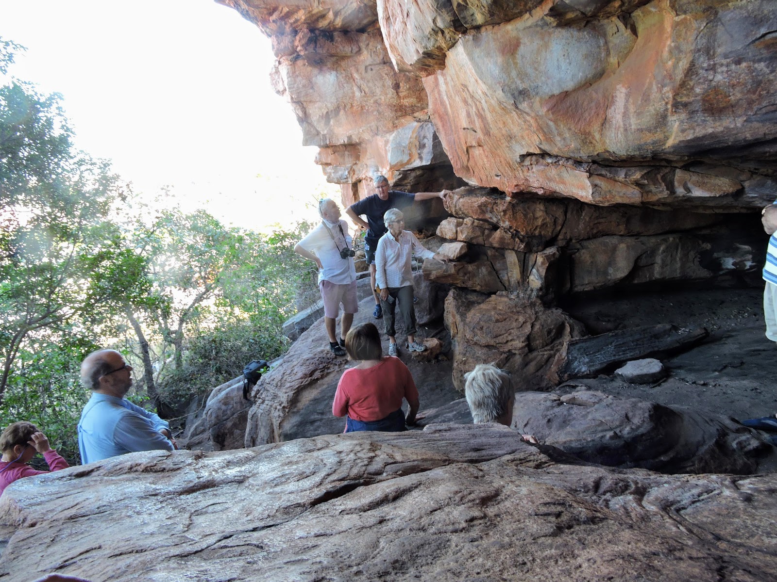
Vansittart Bay, Jar Island: "Gwion Gwion" art
 |
| Jar Island rock art gallery |
The vertical rock faces in Jar Island contain some of the earliest figurative art works in the world. The paintings we saw there showed human figures in elaborate dress with a range of artefacts including spears, boomerangs and various ornaments. Also, some animals. Previously called Bradshaw paintings, after the pastoralist Joseph Bradshaw who first discovered and recorded this style of paintings in 1891, now they are known by different Aboriginal names, the most common of which is Gwion Gwion. The date of the Gwion Gwion rock art is disputed by scientists. In 1994, a technique using optically stimulated luminescence to date fossilized mud wasp nests that were built over Bradshaw figures showed the nests to be 17,000 to 22,000 years old. This finding provides a minimum age dating back to the last ice age. Because this style is so different from later art styles found in Australia, some experts also disputed whether they were created by the same aboriginal people.
Vansittart Bay: C53 plane wreck
 On the Southern end of the bay, just a short distance from Jar Island, we saw the wreckage of a big cargo plane in the bush, not far from the shore. In February 1942, during a return flight from Perth to Broome, the pilot made a navigational error and crash-landed on a salt pan. No lives were lost and the crew members were rescued by a QANTAS flying boat after four days without food in the bush and hot and humid weather. After 75 years the wreck is in amazingly good condition although not likely to be flying again at any time soon.
Swift Bay and Bigge Island: "Wandjina" art
 |
| Wandjinas in Swift Bay |
On the morning of 4 June, we landed in Swift Bay to discover more fascinating art works. Here we saw a very different and more recent style of rock paintings, called Wandjina art, dating back to 4,000 years. Wandjinas are creator beings with special powers in the Aboriginal mythology. The sandstone overhangs in the caves showed several large and variously styled full-bodied Wandjinas with mouthless faces and large eyes with halo-like headdresses. Some animals that are difficult to identify, perhaps a turtle and five heavy-billed birds.
In another nearby gallery on nearby Bigge Island we saw more Gwion Gwion style older paintings of clothes peg-like figures, some in yellow colour. These are thought to be up to 9,000 years old. Some of the old figures are overpainted by more recent (but still several thousand years old) paintings.
 |
| The Mermaid tree |
Careening Bay
This bay was named after the events that occurred here almost 200 years ago. Phillip Parker King, an early explorer travelling around Australia careened his leaky vessel, the Mermaid on this beach in 1820, to repair the leaks. The crew spent 2 weeks here before continuing with the still leaking ship. Behind the beach a majestic old boab tree can be seen bearing the inscription: "HMC Mermaid - 1820".
Camden Harbour
This site is famous for the ill-fated Camden Harbour Pastoral Association. In 1864 farmers from central Victoria had fallen for the extravagant claims of a prospectus lauding the agricultural potential of this 'verdant land'. The settlers arrived on three ships, with 4500 sheep and 36 horses, 200 settlers amongst 8 families and what awaited them was a disaster from the start. They found an almost uninhabitable land, most of their animals and many of the families died. By 1865 the WA government evacuated those who were still there. All that remains today are the few remaining stone walls of the government camp, cleared areas of paths, and a few stone graves.
Rankin Island
 |
| Rankin Island |
On this little island Steve and Alasdair showed us a strange "stucture" made by indigenous people about 3.5-4,000 years ago. Atop of a natural stone mound, a low wall of vertically placed flat stones stretching for over 100 metres. No one really knows who made it and for what purpose. It was most likely built for some ritual or ceremony to "assure" the increase of the catch of fish or game.
Koolan Shelter No. 2
On the last day we passed beside Koolan Island, where we saw a big cave in the middle of the hillside. This is called Koolan Shelter No. 2, where traces of early human habitation were found. The age of the first occupation of the site has been estimated to be about 30,000 years ago. At this time there was relatively high sea level, which meant the sea would have been close to the shelter. People at that time were living off the sea, many shells were found in the cave. As the sea level dropped, the site was abandoned about 24.500 years ago, then re-occupied 10,000 years ago when the sea had returned. People retreated again following the shore line.
------------------
Művészet és Történelem
A Kimberley partszakaszon sok történelmi és művészeti érdekesség található, amikből alkalmunk volt meglátogatni néhányat.
Koolama Bay
Az első, Koolama Bay, mindjárt jun. 2.-án reggel volt. Az öböl a Koolama nevű utasszállító hajóról kapta a nevét. A hajó a 2.VH idején, 1942-ben haladt erre, mikor egy japán bombázó-alakulat megtámadta. Nem süllyedt el, de nem tudta folytatni az útját. A túlélő utasok és személyzet hosszú viszontagságos úton, a csomagjaikat kézben cipelve gyalog jutottak vissza a civilizációba. A hely, ahol partraszálltunk, Tranquil Bay, közel volt ahhoz, ahol a túlélők kijutottak. Az eseményeknek nincs semmi látható helye, de láttunk egy dokumentumfilmet róla, ahol néhány túlélő is elmesélte az emlékeit.
Vansittart Bay, Jar Island: "Gwion Gwion" stílusú sziklarajzok
 A Jar sziget függőleges sziklafalain látható sziklarajzok a világon a legkorábbi figuratív műalkotások közé tartoznak. Ember-alakokat láttunk kar-, láb- és fej-díszekkel, dárdával, bumeránggal, néhány állat-figurát. Egy Joseph Bradshaw nevű farmer talált először ilyen stílusú rajzokat 1891-ben, sokáig őróla nevezték el őket. Ma többféle aboriginal néven ismerik tudományos munkákban, a legismertebb a Gwion Gwion. Az eredetük és keletkezési idejük még most is vitatott a tudósok között. 1994-ben a rajzokra települt és megkövesedett darázsfészkek elemzéséből 17-22-ezer évesre becsülték a darázsfészkek keletkezési idejét. A rajzok ennél csak régebbiek lehetnek. Ez a stílus teljesen más, mint a későbbi Ausztráliában talált sziklarajzok, ezért egyes szakértők kétségbe vonják, hogy ugyanattól az aboriginal népcsoporttól származnak, amelyik ma itt él.
Vansittart Bay: C53 repülőroncs
Az öböl déli oldalán, nem messze a Jar szigettől egy nagy teherhordó repülő roncsait láttuk a fák között. 1942-ben a gép Perth-ből Broome-ba tartott, mikor a pilóta eltévedt, kifogyott az üzemanyag, és kényszerleszállást hajtott végre. A személyzet túlélte a leszállást és 4 napi étlen-szomjan várakozás után egy Qantas hidroplán kimentette őket. A roncs meglepően jó állapotúnak tűnik 75 év után a forró-nedves klímában, de egyhamar nem fog újra repülni.
Swift Bay és Bigge Island: "Wandjina" stílusú sziklarajzok
 |
| Egy Wandjina (Bigge Island) |
Jún. 4.-én reggel szálltunk partra a Swift öbölben. Itt a korábbitól nagyon különböző stílusú és sokkal fiatalabb sziklarajzokat láttunk, amit Wandjina stílusnak hívnak és kb 4-ezer évesre becsülik. Az aboriginal mitológiában a Wandjina-k különleges képességekkel rendelkező teremtő lények. A barlangok szikla mennyezetén több nagy Wandjina nézett le ránk hatalmas szemekkel, száj nélküli arccal, koszorú-alakú fejdísszel. Néhány nehezen azonosítható állatfigurát is láttunk, talán egy teknőst, egy sor vastag csőrű madarat.
Egy másik közeli helyszínen a Bigge szigeten újabb Gwion Gwion stílusú rajzokat láttunk, hosszú vékony emberalakokat sárgára festve. Ezeket 9-ezer évesre becsülik. A régebbi figurák néhol át vannak festve újabb (de szintén többezer éves) rajzokkal.
Careening Bay
Ezt az öblöt egy 200 évvel ezelőtti eseményről nevezték el (careening azt jelenti hogy egy hajót megdöntve partra tenni). Phillip Parker King, egy korai felfedező Ausztrália körül utazva ebben az öbölben partra tette a léket kapott Mermaid nevű hajóját, javítás céljából. Két hetet töltöttek itt, aztán tovább indultak, bár a léket nem sikerült teljesen kijavítani. Az eseményből egy látható emlék maradt: a hajóács a part mögötti hatalmas boab fa törzsébe belevéste a hajó nevét és az évet: "HMC Mermaid - 1820". A graffiti a fa törzsével arányosan hatalmasra nőtt az azóta eltelt 200 év alatt.
Camden Harbour
 |
| Camden Harbour |
Ez a hely is szomorú emlékeket hordoz. 1864-ben Victoria állam-beli farmereket megszédített egy prospektus ami ennek a vidéknek a hatalmas mezőgazdasági potenciálját dícsérte (alaptalanul). 200 telepes nekivágott az útnak három hajón 4500 birkával és 36 lóval. Katasztrófa várta őket az első naptól kezdve. A terület teljesen lakhatatlannak bizonyult, állataik nagyrésze és sokan a telepesek közül hamarosan meghaltak. 1865-ben a Nyugat Ausztráliai kormány segítségével hagyták el a helyet azok, akik még életben voltak. Ma már csak néhány omladozó kőfal és elvadult ösvény látható, egy pár sírhely, és néhány bronz emléktábla a fákban amit a leszármazottak helyeztek el.
Rankin sziget
Ezen a kis szigeten egy furcsa építményt láttunk amit 3.5-4-ezer éve készítettek az ittlakók. Egy nagyobb méretű kövekből álló természetes domb élén áll egy élére állított lapos kövekből kirakott alacsony fal, több mint 100 méter hosszan. Nem tudni, ki és milyen célból építette. A legvalószínűbb feltevés szerint valamilyen rituális célt szolgált, talán a halászat vagy vadászat eredményének biztosítására.
Koolan Shelter No. 2
 |
| A barlang szája Koolan szigeten |
Az utolsó nap az Explorer-ben elhaladtunk a Koolan sziget mellett, ahol egy nagy barlang száját láttuk a domboldal közepe táján. Ezt hívják Koolan Shelter No. 2-nak, ahol korai emberi lakóhely nyomait találták. A legkorábbi nyomok korát 30-ezer évesre becsülik. Abban az időben a tengerszint magasabb volt, a barlang közel lehetett a vízhez. Az itt élő emberek a tengerből éltek, sok akkor élt kagylófajtát találtak a barlangban. Később a tengerszint lesűlyedt és a barlang lakatlanná vált 24.5-ezer évvel ezelőtt, majd újra benépesült 10-ezer évvel ezelőtt amikor a tenger megint felemelkedett. Később az emberek ujra visszavonultak ahogy a tengerpart is visszahúzódott.


 One afternoon, and on the morning of our last day we went into town by bus, for a walk around the centre to re-visit so mother interesting places, the history museum, and the site of the Sisters of St John of God convent, which is now a heritage centre with a vast archive of photos and documents about the history of the convent. Kate also visited the old Japanese cemetery, while I worked on our photo collections in the hotel.