Sunday, 10 June, Merl campground, Kakadu NP - Around midnight we wake up to cracking noise and thick smoke: the bush around the Kakadu Lodge caravan park is on fire, no more than 20 metres from our van. We get up and walk around, find a few people watching the fire but they don't seem to be concerned at all. Even if it is not dangerous, it is very irritating. We go back to bed but it's not a good night sleep.
In the morning we go out to the town centre of Jabiru. We find the shopping centre but everything is deserted on an early Sunday morning. Fortunately the supermarket - quite big and well stocked - opens at 9 am so we can buy some water and other necessities. Then we head back to the caravan park, pack up and drive to the East Alligator River region, at the border between Kakadu NP and Arnhem Land, a protected aboriginal area only accessible by special permit. It is only an hour drive, and by 11 am we set up the van in the Merl campground, a picturesque shady park with basic facilities.
We go around to discover the area, Cahills Crossing, the only road leading to the Arnhem Land across the river, the boat ramp and the Border Store, where we book a river cruise for 3 pm. Then we go back to the van for lunch and a good rest.
 |
| Robert throwing a spear |
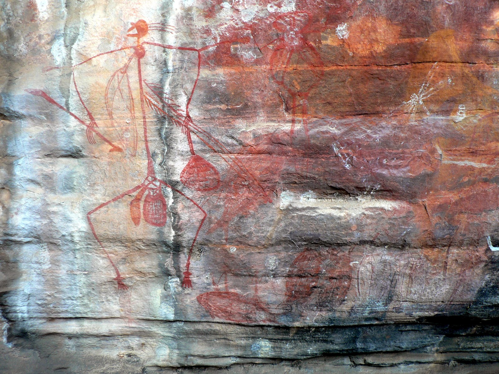 |
| Ubirr - Mimi spirits with woomera |

We go back to the camp to cook and eat dinner in a hurry, because at 8pm there is a slideshow presentation by a ranger about aboriginal rock art. The air is very pleasant in the evening, fortunately no fires around, but plenty of mosquitos, fortunately we are well prepared for them. Overall a very nice and eventful day, followed by a good sleep.
Monday, 11 June, Merl campground - In the morning we go up to the Border Store to enquire about scenic flights over Jim Jim Falls. We are told that there is no more flights above the falls because the road to the falls opened on Saturday morning. It is a welcome change, we can then go there on our own later.

 |
| With Miriam |
Tuesday, 12 June, Muirella Park - We left the Merl campground quite early and by 9 am we were back at Jabiru, to do some shopping, fill up the tanks (with Diesel and water) and to download our emails, send a few quick responses and make a few phonecalls. The next stop was the Bowali Tourist Information Centre, just beside Jabiru at the Park headquarters. It is a nice building, with interesting displays of the natural and cultural life of Kakadu NP. We inquire about the trip to Jim Jim Falls and learn that it is open but the Twin Falls is not, but still there are no more scenic flights above that area.
Then we drive another 30 km SW to the Nourlangie region, and set up camp at the Muirella Park, another campsite managed by NPWS, but not as nice as Merl was. We stay at the van for lunch and a long rest, to wait out the hottest part of the day.
 |
| The rock shelter |
 |
| Namarnjolg and Namarrgon the Lightning Man |
Back at the camp there is another ranger talk about animals in Kakadu, but we are too tired and have our usual evening program to do, so we give it a miss.
Wednesday 13 June, Mardugal campground - We got up early morning to do the "Bubba" walk, a 3.5 km circuit around wetlands just beside the camp. We drove to the parking area to find that the walking track is closed, still under water. So we go back, have breakfast and then drive to our next destination, the Yellow Water area, only about 30 km away. There is another managed campground, Mardugal, where we set up camp again. The area is quite deserted, only a few other campers around.
Then we head to the Cooinda Lodge a few km's back and book a boat tour on the Yellow Water wetlands for the afternoon. There is also a walking track along the wetlands that we want to do - and again we are told that it is not open yet, the water level is too high. We go then to the nearby Warradjan Aboriginal Cultural Centre, and walk through the displays explaining aboriginal way of life and the nature, flora and fauna of the Kakadu NP region. Quite interesting and very well presented.
As there is nothing else to do here, we go back to the van to have lunch and a nice long siesta. Around 4 pm we go back to the Cooinda Lodge, first to get a bit more info about our destination tomorrow: Jim Jim Falls. We know that the road has just opepend last Saturday, but we are told that all the walking tracks are still closed, the only thing we can do is to stop at the carpark, walk straight to the plunge pool below the falls, have a swim if we want, then come back. It is surprising (to me at least) that still in mid-June there are so many attractions closed. From the guidebooks I thought that the tourist season starts in May, I expected that mid-June is already the high season, but obviously I was mistaken. It must have been a pretty heavy wet season this year to take it that long to clean up. But that explains whye there are not that many people around, which we don't mind...

 |
| Lotus lilies in Yellow Water |


When we got back to the main road, we did a little detour back to the Nourlangie region, to check out the Mirrai lookout. It is a 1.6 km steep climb up to Mount Cahill to a platform with 360 degrees views, but it was quite a disappointment. The surrounding trees mostly overgrown the lookout and the air was very hazy, there was not much to see, more to just imagine. Nevertheless, it was good exercise in the afternoon heat...
Then we went back to the camp for a bit of rest and a quiet evening.
Friday, 15 June, Katherine - Our plan for today was to drive to Gunlom, and to spend the day in the Mary River region of Kakadu NP, doing a few walks around the area. There is a 37 km unsealed road from the Kakadu Hwy to Gunlom, and we were warned that it is very corrugated. We got to the turnoff, started on the gravel, but gave up after 5 kms. It was unbearable! The whole car (and of course the van as well, even if we could not feel it) was resonating like sitting in an electric chair (although I haven't done that, but that's how I can imagine it). So we decided that it could not be THAT interesting, and turned back.
It is a big disappointment, not just for not seeing this area, in fact, I think we have covered the most famous and interesting sites of Kakadu NP that were open, but it is a bad omen for our planned future itinerary. What are we going to do if the Gibb River Road, that we plan to follow for the whole 600 kms, is as bad as this one? So we are a bit shaken and uncertain about the future.
But for now, we have finished with Kakadu NP. We spent 6 days in there, and most of it was really beautiful, despite the bad ending. By lunchtime we got to Katherine, and set up camp in a nice caravan park. In the afternoon we had some time to rest and plunge into the nice little pool in the park, then to stock up and fill up in town, to prepare for the next part of the trip.
Tomorrow we head East on the Victoria Highway, Western Australia awaits us!
Our itinerary can be seen at the following Google Map:
http://g.co/maps/wcwv8
(Note that to see the route after Bowen, you need to move down to the bottom of the right panel, and select the following pages!)
Az elmúlt hetet a Kakadu nemzeti parkban töltöttük. Végigjártuk nagyjából az összes elérheto nevezetességet. Ez a vidék elsosorban az aboriginal emlékeirol híres, no meg a természeti szépségeirol, ezért kapott Világörökségi státuszt. Több helyen láttunk régi sziklarajzokat, egyik-másikat húszezer évesre becsülik. A helybeli (kevés megmaradt) aboriginek folyamatosan megtartották a régi kultúrájukat, ez is elég egyedi jelenség a világon. Meghallgattunk több ingyenes kiseloadást a helyi kultúráról, a sziklarajzok értelmezésérol, a növény- és állatvilágról, ezeket a park-rangerek (felügyelok) tartják az érdeklodoknek. Az egyik rangerrel beszélgettünk egy kicsit, kiderült, hogy Tasmániából van itt 6 hónapos csere-programon, és ismeri Jodi-t és Marcit. Kicsi a világ.
Egy kellemetlen dolgot meg kell szokni itt: valahol állandóan ég a bozót. Az elso éjszaka a kemping oldalában, a lakókocsinktól pár lépésnyire égett a bozót, fojtogató füstre és a tuzropogásra ébredtünk éjfél körül, kimentünk, két ember nézelodött a közleben, de nem izgatták magukat, ez itt így van rendjén. A száraz évszak kezdetén folt-szeruen gyújtogatják a bozótot, foleg délután, estefelé, amit aztán az éjszakai lehulés és harmat elolt. Így redukálják az égheto anyagok mennyiségét, mire a nagyobb szárazság megjön, ne legyen minek égnie. Most már legalább értjük a dolgot, és nem olyan ilyeszto, de attól még ugyanolyan kellemetlen a fojtogató füst és az állandó homályos levego.
Voltunk két hajótúrán is, az egyik az East Alligator River-en, ami a park keleti határa, egy helyi aboriginal vezetovel, aki sok érdekeset mesélt az életükrol, a különféle növények felhasználásáról, és bemutatta nekünk a dárda-veto tudományát, amit még o is megtanult gyerekkorában. A másik a Yellow Water wetlands túra volt, ez egy vizzel borított árterület, fantasztikus madárvilággal, a South Alligator river mellett. Két órát hajókáztunk fel-s-alá, rengeteg érdekes madarat és növényt láttunk, nem tudom felsorolni a nevüket angolul sem, nemhogy magyarul, de nagyon élveztük. Láttunk jó pár nagy sósvizi krokodilt is (ez az emberre is veszélyes fajta), meg vaddisznót.
Csütörtökön meglátogattuk a park egyik nevezetességét, a Jim Jim vízesést. 55 km földút vezet oda, amibol az elso 45 könnyu csak kellemetlen, mert "corrugated", nem tudom hogy mondják magyarul, talán bordázott?, az egész autó rezonál ahogy a kerekek ugrálnak a suru bordázaton. Az utolsó tíz km viszont elég nehéz keskeny, kanyargós csapás, helyenként mély puha homokban, sok víz-átfolyással, szóval az autónk összes terepjáró képességeire szükség volt hogy odajussunk (persze a lakókocsit nem vittük). Aztán még jött egy 1 km-es gyalogút, az sem volt könnyebb, hatalmas össze-vissza dobált sziklán kellett átmászni hogy odajussunk, de megérte, fantasztikus látvány. Egy kb 150 m magas függoleges sziklafal tetejérol zuhog a víz egy kis kerek medencébe, egy szuk sziklavölgyben. A száraz évszakban lassan teljesen elapad a víz de most még elég erosen folyt. Sajnos a szuk völgyben és árnyékban jó huvös volt és eros szél, nem sokáig volt kedvünk maradni, nemhogy fürödni. A másik híres látnivaló, a Twin Falls, tíz km-el messzebb, még nem látogatható, még járhatatlan az út. De így is érdekes kirándulás volt.
Ma reggel azt terveztük, hogy dél felé az utolsó területre megyünk a parkban, a Mary river folyó környékén. Oda is 37 km-t földúton kellett menni. El is indultunk rajta, de 5 km után feladtuk, nem bírtuk a borzasztóan eros "corrugation"-t. Nemcsak nekünk nagyon kellemetlen a zaj meg a rázkódás, de az autónak meg a lakókocsinak is nagyon árthat. Ugyan mindketto terep-viszonyokra van tervezve, lehet hogy feleslegesen aggódunk?... Így aztán visszafordultunk, búcsút mondtunk a Kakadu nemzeti parknak, és továbbjöttünk Katherine-ig. Délre ideértünk, megszálltunk egy kempingben, délután pihentünk, fürödtünk a kemping jó kis úszómedencéjében, aztán jól bevásároltunk, feltöltöttük a készleteinket a következo hétre.
Holnap indulunk tovább Western Australia felé.
Az útvonalunk a következo Google Map-on látható:
http://g.co/maps/wcwv8
(A Bowen utáni szakaszokhoz le kell menni a jobboldali panel aljára, és a következo oldalakra kattintani!!)
No comments:
Post a Comment