Thursday 21 June 2012

Kununurra, WA

(Magyar összefoglaló a végén)


A boab tree
Saturday, 16 June, Saddle Creek Rest Area - Not much to report. In the morning we took advantage of the good internet connection to upload the next posting to our blog site, then packed up and left Katherine on the Victoria Highway. We travelled all day with a lunch stop at the Victoria Roadhouse, and stopped a little before the Western Australian border. Just after Timber Creek we saw the first boab trees, an indication that we are getting close to WA. This Saddle Creek rest area is a very popular spot, because it is under a beautiful red rock escarpment. We got here around 5 pm and the area was almost fill, but we could still find a space to set up the van. Kate had a lot of cooking to do, to make use of all the vegetables that otherwise would have to be thrown out at the WA border.


It was a very hot day, the hottest so far that we experienced. 34 degrees all afternoon, and even now, more than an hour after sunset it is above 30 degrees in the van. The fan in the ceiling does not help much. Hope it will cool down a bit more over the evening so that we can sleep. 


Sunday, 17 June, Kununurra - It took a long time yesterday evening to cool down, and even the night was warm, at sunrise it was still 24 degrees. Just an hour after breakfast we got to the WA border, with two short stops to finish off with our remaining fruit supply that can't be taken to WA. The quarantine inspection went smoothly and quickly, no problems. By around 11 am we gont into Kununurra.


In fact, it was 11 am Northern Territory time, but in WA it was only 9.30 am, a big change, showing how far we came from Sydney, 2 hours time difference. But both NT and WA times are a bit misaligned with the "real" time of day. In NT sunrise was only around 7.15 am, and sunset at 6.15 pm, now in Kununurra we just saw the sun going down exactly at 5pm. Anyway, we will get used to it.


Our campsite in Kununurra
We booked into a lakeside caravan park; it was not simple, first we were told to wait as there were no more powered sites available, but finally we've got the nicest site that we ever had before, a big well shaded grassy place among palm trees normally reserved for groups. We spent most of the day in the camp, plunging in the pool and resting. Late afternoon we went for a little drive to discover the town, did some shopping and climbed up to a lookout just beside the town centre, Kelly's Knob. Beautiful views of the surrounding rocky landscape and the town and lake in the evening lights, well worth the effort.
View of Kununurra from Kelly's Knob
We have now passed more than two months on the road, one-third of our planned trip, and travelled more than 10 thousand kms. Fortunately we are still enjoying the experience and each other's company... Another milestone to mention is that now that we entered WA, we have visited each Australian state.


Monday, 18 June, Kununurra - It was strage to wake up to daylight around 6 am, 1.5 hours earlier than in NT, but we can easily get used to this. In the morning we went to Lake Argyle, about 70 kms from here. It is a nice easy and scenic drive among various red rock outcrops characteristic of the Kimberley region. 
First we visited the Durack Homestead, moved up from its original place which is now under water and rebuilt as a museum showcasing the early life and the history of the Durack family. 


Then we went on to several lookout points to get a view of the Ord River Dam and Lake Argyle, a vast man-made lake 21 times the size of Sydney Harbour. It is a beautiful sight the dark-blue water in between the red rock ranges with a bit of lush vegetation around the lake.
The Ord River Gorge below the dam
A curious bird at the Lake Argyle picnic area
By midday we were back in town and dropped in the Visitor Centre to get some info on the Gibb River road, but we did not hear anything new.
We spent the afternoon in the camp, resting and chatting with a couple of fellow Eco Tourer owners, Brian and Maree, discussing our travel experiences and little tricks about our van.


Tuesday, 19 June, Kununurra - Today we did an excursion to Wyndham, the Northernmost town in WA, about 100 km from Kununurra. On the way up we made a detour on 23 km dirt road to see the "Prison Tree", a very old, enormous boab tree, with a huge cavity in its trunk, that was used in the early days to keep prisoners locked up inside overnight. The tree is said to be more than 2 thousand years old. It is a very interesting sight indeed. 


The rivers at Wyndham Port
Wyndham is a small and fairly desolate sleepy little town, not much life in it. There is a nice lookout above it, called the Five Rivers lookout (or the Bastion), because one can see five rivers: King, Pentecost, Durack, Forrest and Ord River, coming together and flowing into the Cambridge Gulf. There is a little port with very little movement in it. There was a meatworks until the mid-80s but when it closed, the town has started to decline. There is a crocodile farm as a tourist attraction that is not attracting many tourists, at least right now. 


Another giant boab tree in Wyndham
There is a small museum that we visited, showing life and history of the town and surroundings, it was quite complete and interesting. We had lunch in the Wyndham Town Hotel, that looked abandoned from the outside, and poorly maintained from the inside, but the pan-fried barramundi was not too bad. Overall, an interesting experience, but not one of the top destinations in our trip.


On return to Kununurra we did some shopping then a quiet afternoon at the camp.


Wednesday, 20 June, Kununurra - This morning we had to move to a different place in the caravan park because a group was coming to the place originally given to us. It was only a short distance, but still we had to pack up the van completely and then set it up again, it took about an hour. Our new place is just beside the pool, also quite nice, apart from the continuous buzzing of the pool machinery day and night but we have to live with that, and we can.


At the Hoochery Distillery
Then we went on a little tour of attractions around Kununurra: first the plantations irrigated by the Ord River channels and the Sandalwood Factory, where we glanced through all the various cosmetics on offer, all made of sandalwood oil. Then to the Hoochery Distillery, where they make rum and different kinds of liquers from sugarcane. We sampled some of the products and ended up buying a few for later enjoyment. 


The Ivanhoe Crossing
From there we drove to the Ivanhoe Crossing, where an old road is going across the Ord River at a ford. Although the water level is just about 10-15 cm above the cemented ford, the crossing is closed to vehicles as the water is flowing very fast. It is an interesting place to look at, and seemingly very popular with local (and tourist) fishermen.


We came back to the camp by lunchtime and spent a lazy afternoon reading and resting.


King George Falls

Thursday, 21 June, Kununurra - Today we went on a scenic flight around the Northern coast of the Kimberley. It was a very small aircraft, a Cessna-210, with a young female pilot. The flight took 4.5 hours, but it took almost all day with a stopover in Kalumburu, the Northernmost community in WA. It is hard to describe in words the magnificent scenery we saw all the way. There were several highlights: the North coastline with its pristine beaches and clear green-blue waters of the Timor sea, the King George Falls, and in the afternoon the Mitchell Falls and the Cockburn Ranges.


The altar in the Mission Temple
Kalumburu started off as a Benedictine Mission at a different place called Pago in 1913, then moved to the current location in 1931. There were monks and nuns, the last of which left only a few years ago and the township is now managed by the aboriginal community. But the Mission is still alive and working for the community. We visited the mission and the museum established by the missionaries from 1984. It has a large collection of artifacts, local and from other parts of Australia and the world. It also presents the past and present history of the town. 


After the museum we also saw the site where two WW2 aircrafts crashed, the scattered parts of the fuselage are still very impressive.
Apart from the highlight tourist attractions, flying low above the earth in a small plane is in itself a very interesting experience, almost any part of the landscape seems so beautiful from above. We thoroughly enjoyed this experience. We have several anniversaries coming up in the next few days, this was a collective present for both of us.
The Mitchell Falls
The Cockburn Ranges and the Gibb River Road
It was about 4 pm by the time we got back to the camp, so there was no time for anything else, but this flight tour was enough excitement for a day. 
Tomorrow we head off to the Bungles!


Our itinerary can be seen at the following Google Map:
http://g.co/maps/wcwv8 
(Note that to see the route after Bowen, you need to move down to the bottom of the right panel, and select the following pages!)


Szombaton reggel elindultunk Katherne-bol, és egy éjszakai szabad-kempingezés után vasárnap reggel átléptünk Nyugat-Ausztráliába és délelott 11 felé meg is érkeztünk Kununurra-ba. Pontosabban a határ-átlépéssel az órát is vissza kellett állítani másfél órával, úgyhogy itteni ido szerint fél tízkor érkeztünk. Hozzá kell szokni ehhez az ido-különbséghez. Eddig a Northern Territory-ban hét után kelt csak a nap, és este negyed 7 körül volt naplemente. Itt meg már reggel 6-kor kel a nap, viszont este 5-kor megy le, így jó hosszú téli estéink vannak. Igaz, hogy közel vagyunk a legrövidebb naphoz, ez nem is olyan meglepo.
Kununurra egy elég kis város, de a fo turista-idényben, ami most kezdodik, nagyon felduzzad, rengeteg a magunkfajta "gray nomad", no meg pár fiatalabb utazó, mi is elég nehezen kaptunk helyet a lakókocsinknak. Ez az észak-keleti kezdopontja a Kimberley-régiónak, az itteni leghíresebb turista-nevezetességnek.
Vasárnap óta itt töltöttük az idot, kisebb kirándulásokat tettünk a környéken, és sokat pihentünk ebben a kellemes kempingben. Egyik nap elmentünk a Lake Argyle-hoz, egy hatalmas mesterséges tó az Ord folyó gátja fölött. Több szép kilátó pontról lehet körülnézni a tóra és a környezo tipikus vöröses-barna szikladombokra. Mellette meglátogattunk egy régi farmházat is a 18. szd végérol, az egyik elso híres farmer család, a Durack család eredeti farmházát, amit szétszedtek és ujra felépítettek itt amikor a duzzasztás elkezdodött.
Egy másik nap kirándultunk Wyndham-ba, 100 km északra egy kis kikötovárosba, ami nem volt nagyon érdekes. Alig van benne élet mióta megszunt a mellette korábban muködo hús-feldolgozó üzem. Viszont a környezete elég érdekes, öt folyó jön itt össze egy kis helyen és közös torkolattal folyik a Cambridge öbölbe. Van egy kilátó-pont a városka fölött ahonnan mind az öt folyót be lehet látni. Egy másik érdekességért 23 km-es kitérot tettünk földuton: az ún. "börtön-fa", egy óriási boab-fa, aminek üreges a belseje és van egy nagy luk az oldalában, a régi idokben a rendorök útközben ide dugták be a foglyot éjszakára. A fa enélkül is csak a méreteivel fantasztikus látvány, több mint kétezer évesre becsülik. Láttunk egy másik hasonló méretu óriást is Wyndham-ban, luk és más történet nélkül, de az is gyönyöru volt.
Itt a környéken megnéztük a duzzasztóvból öntözött területeket, ahol most leginkább indiai sandal-fákat nevelnek, megnéztük a gyár bemutató-termét ahol remgeteg kölönféle kozmetikumot készítenek a fából sajtolt olajból. Aztán megnéztünk egy lepárló üzemet, ahol cukornádat dolgoznak fel, rumot és többféle likort csinálnak belole. Kóstolót is kaptunk, és végül vettünk is egy kis tartalékot a további útra.
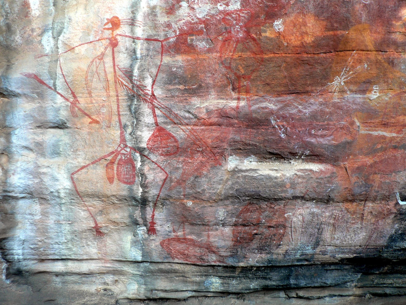
Ma pedig egész különleges élményben volt részünk: elmentünk egy repülos kirándulásra. Majdnem egésznapos túra volt egy kis ötszemélyes gépen (Cessna-210) egy szimpatikus fiatal no pilótával, rengeteget láttunk, 4 és fél órát repültünk, fel a kontinens északi partja mentén nyugatra és kicsit délebbre vissza egy nagy körben, közben egy sor nevezet természeti szépséget láthattunk, folyóvölgyeket, vízeséseket, sziklás hegyláncokat, elhagyott tengerparti öblöket a Timor tenger partján. Délben leszálltunk egy Kalumburu nevu kis aboriginal faluban, ebédet is kaptunk és megnéztük a "misszió"-t amit Benedek-rendi barátok alapítottak 1913-ban. Láttuk a múzeumot rengeteg érdekes rajzzal-képpel faragással, és a misszió történetével. A nevezetsségek mellett maga a kis repüloben alacsonyan repülés is nagyon érdekes ujdonság volt nekem, a föld jelentéktelenebb részei is olyan szépek fölülrol. Persze jó sokba került, de nagyon élveztük, megérte. Ez volt a közös ajándék mindkettonk közeli ünnepeire.


Holnap reggel aztán tovább indulunk a következo látványosság felé.


Az útvonalunk a következo Google Map-on látható:
http://g.co/maps/wcwv8
(A Bowen utáni szakaszokhoz le kell menni a jobboldali panel aljára, és a következo oldalakra kattintani!!)

Friday 15 June 2012

Kakadu National Park

(Magyar összefoglaló a végén)
Sunday, 10 June, Merl campground, Kakadu NP - Around midnight we wake up to cracking noise and thick smoke: the bush around the Kakadu Lodge caravan park is on fire, no more than 20 metres from our van. We get up and walk around, find a few people watching the fire but they don't seem to be concerned at all. Even if it is not dangerous, it is very irritating. We go back to bed but it's not a good night sleep.


In the morning we go out to the town centre of Jabiru. We find the shopping centre but everything is deserted on an early Sunday morning. Fortunately the supermarket - quite big and well stocked - opens at 9 am so we can buy some water and other necessities. Then we head back to the caravan park, pack up and drive to the East Alligator River region, at the border between Kakadu NP and Arnhem Land, a protected aboriginal area only accessible by special permit. It is only an hour drive, and by 11 am we set up the van in the Merl campground, a picturesque shady park with basic facilities. 


We go around to discover the area, Cahills Crossing, the only road leading to the Arnhem Land across the river, the boat ramp and the Border Store, where we book a river cruise for 3 pm. Then we go back to the van for lunch and a good rest.


Robert throwing a spear
At 3 pm we go back to the boat ramp for the Guluyambi Cultural Cruise along the East Alligator River. We go upstream with a local aboriginal guide, who explains the surrounding sights and vegetation, the various uses of certain trees and grasses. We also have a chance to step out on the Arnhem Land side of the river for a few minutes to appreciate the rock escarpment and the river, and our guide, Robert, demonstrates his spear-throwing ability. Then we head back downstream to the ramp. It was a 2-hour very enjoyable cruise apart from 4 young and very loud Germans who were more interested in making fun of each other than the surrounding environment.


Ubirr - Mimi spirits with woomera
After the cruise we drive up to Ubirr, only 3 km further North, one of the main Aboriginal rock art sites in Kakadu. A short walk takes us to several fascinating rock painting sites. Unfortunately it is very crowded, this is one of the most famous places in the NP, every bus tour comes here. Still, the paintings are worth coming here. 


Then we climb up - together with everybody else - to the Nadab lookout to see the sunset over the floodplain and the rocky landscape, a spectacular view. 


We go back to the camp to cook and eat dinner in a hurry, because at 8pm there is a slideshow presentation by a ranger about aboriginal rock art. The air is very pleasant in the evening, fortunately no fires around, but plenty of mosquitos, fortunately we are well prepared for them. Overall a very nice and eventful day, followed by a good sleep.


Monday, 11 June, Merl campground  - In the morning we go up to the Border Store to enquire about scenic flights over Jim Jim Falls. We are told that there is no more flights above the falls because the road to the falls opened on Saturday morning. It is a welcome change, we can then go there on our own later.


Then we walk along the Bardedjilidji track, a 2.5 km walk through layered sandstone outliers and billabongs. We go back to the van and decide to stay here for the day; it is such a nice spot and we are happy to have a lazy day not "working" (that is, sightseeing...) for a change. So we stay at the van most of the day resting and reading. Despite all the mosquitos around we enjoy a few hours sitting outside in the shade.


With Miriam
Just after 5 pm we drive back to Ubirr, to walk along the art sites to have a second look at the rock paintings, then climb up to the lookout for a second serving of a beautiful sunset. We also listen to a talk about the aboriginals connection to the land. It is given by a sympathetic female ranger with whom we start chatting after the talk and find out that she is on a 6-months swap program from Tasmania, and it turns out that she is friends with Jodi and Martin, our son and his partner. A small world ...


Tuesday, 12 June, Muirella Park - We left the Merl campground quite early and by 9 am we were back at Jabiru, to do some shopping, fill up the tanks (with Diesel and water) and to download our emails, send a few quick responses and make a few phonecalls. The next stop was the Bowali Tourist Information Centre, just beside Jabiru at the Park headquarters. It is a nice building, with interesting displays of the natural and cultural life of Kakadu NP. We inquire about the trip to Jim Jim Falls and learn that it is open but the Twin Falls is not, but still there are no more scenic flights above that area.


Then we drive another 30 km SW to the Nourlangie region, and set up camp at the Muirella Park, another campsite managed by NPWS, but not as nice as Merl was. We stay at the van for lunch and a long rest, to wait out the hottest part of the day. 


The rock shelter
Around 3 pm we drive back about 20 km to the actual area of interest around here, Nourlangie. It is another famous aboriginal art gallery, with lots of well-know rock paintings. But the rock formations and surrounding cliff faces are just as impressive as the paintings themselves. There is an amazing ancient rock shelter, several other art sites and a lookout to the whole area up to the main Arnehmland escarpment. We listened to several short talks given by another park ranger, about the archeological findings, the meaning of some of the paintings and the landscape and its importance to the local people. 


Namarnjolg and Namarrgon the Lightning Man
Just before sunset we drive to the other side of the rock outcrop, a few kms on gravel road, then a 2 km walk to another rock art site called Nanguluwur. We have to do it in a hurry to get back to the car before nighfall, so we can only spend a few minutes there, but we saw some other interesting paintings that were worth a look.


Back at the camp there is another ranger talk about animals in Kakadu, but we are too tired and have our usual evening program to do, so we give it a miss.


Wednesday 13 June, Mardugal campground - We got up early morning to do the "Bubba" walk, a 3.5 km circuit around wetlands just beside the camp. We drove to the parking area to find that the walking track is closed, still under water. So we go back, have breakfast and then drive to our next destination, the Yellow Water area, only about 30 km away. There is another managed campground, Mardugal, where we set up camp again. The area is quite deserted, only a few other campers around. 


Then we head to the Cooinda Lodge a few km's back and book a boat tour on the Yellow Water wetlands for the afternoon. There is also a walking track along the wetlands that we want to do - and again we are told that it is not open yet, the water level is too high. We go then to the nearby Warradjan Aboriginal Cultural Centre, and walk through the displays explaining aboriginal way of life and the nature, flora and fauna of the Kakadu NP region. Quite interesting and very well presented. 


As there is nothing else to do here, we go back to the van to have lunch and a nice long siesta. Around 4 pm we go back to the Cooinda Lodge, first to get a bit more info about our destination tomorrow: Jim Jim Falls. We know that the road has just opepend last Saturday, but we are told that all the walking tracks are still closed, the only thing we can do is to stop at the carpark, walk straight to the plunge pool below the falls, have a swim if we want, then come back. It is surprising (to me at least) that still in mid-June there are so many attractions closed. From the guidebooks I thought that the tourist season starts in May, I expected that mid-June is already the high season, but obviously I was mistaken. It must have been a pretty heavy wet season this year to take it that long to clean up. But that explains whye there are not that many people around, which we don't mind...


Then we board the boat and go on a 2-hour cruise around the Yellow Water wetlands. It is hard not to write in awe about it, as it was so fantastic. The scenery and vegetation are all so beautiful, the water lilies and lotus in flowers, the paperbarks, the grassland... but the highlights are the birds and other animals. We saw many different types, cormorants, snake-necked darter, whistling ducks, egrets, herons, kingfisher, magpie geese and some others that I forgot the names. Also quite a few crocodiles, all "salties", one very big one, a black pig... 
Lotus lilies in Yellow Water
To top it off, the tour finished with another magnificent sunset above the wetland. This was definitely one of the highlights of our Kakadu trip so far.


Thursday, 14 June, Mardugal campground - Today we went to Jim Jim Falls. It is a 55 km gravel road, the first 45 is wide and easy just dusty and some section very corrugated. The last 10 km is a narrow 4WD track, quite difficult at some places, deep soft sand, and some small water crossings. We did it without any problems, thanks to our very good and capable car. 


After the drive there is a 1-km walk to the bottom of the falls, which is equally difficult, scrambling from rock to rock, it took almost an hour to get there. We got there quite early, around 11 am, one little tour group just left, so the whole place was just ours for a while. 


It is an amazing place. A narrow valley among towering vertical rock faces about 150 m high. The water is still flowing a bit and there is a large pool underneath, but it was quite cold and windy and the water itself was very cold, we had no desire to jump in. After about half an hour we just walked back to the car and drove to the camping area where we stopped for lunch and coffee, our daily indulgence. 
When we got back to the main road, we did a little detour back to the Nourlangie region, to check out the Mirrai lookout. It is a 1.6 km steep climb up to Mount Cahill to a platform with 360 degrees views, but it was quite a disappointment. The surrounding trees mostly overgrown the lookout and the air was very hazy, there was not much to see, more to just imagine. Nevertheless, it was good exercise in the afternoon heat...
Then we went back to the camp for a bit of rest and a quiet evening.


Friday, 15 June, Katherine - Our plan for today was to drive to Gunlom, and to spend the day in the Mary River region of Kakadu NP, doing a few walks around the area. There is a 37 km unsealed road from the Kakadu Hwy to Gunlom, and we were warned that it is very corrugated. We got to the turnoff, started on the gravel, but gave up after 5 kms. It was unbearable! The whole car (and of course the van as well, even if we could not feel it) was resonating like sitting in an electric chair (although I haven't done that, but that's how I can imagine it). So we decided that it could not be THAT interesting, and turned back.


It is a big disappointment, not just for not seeing this area, in fact, I think we have covered the most famous and interesting sites of Kakadu NP that were open, but it is a bad omen for our planned future itinerary. What are we going to do if the Gibb River Road, that we plan to follow for the whole 600 kms, is as bad as this one? So we are a bit shaken and uncertain about the future.


But for now, we have finished with Kakadu NP. We spent 6 days in there, and most of it was really beautiful, despite the bad ending. By lunchtime we got to Katherine, and set up camp in a nice caravan park. In the afternoon we had some time to rest and plunge into the nice little pool in the park, then to stock up and fill up in town, to prepare for the next part of the trip.


Tomorrow we head East on the Victoria Highway, Western Australia awaits us!


Our itinerary can be seen at the following Google Map:
http://g.co/maps/wcwv8 
(Note that to see the route after Bowen, you need to move down to the bottom of the right panel, and select the following pages!)


Az elmúlt hetet a Kakadu nemzeti parkban töltöttük. Végigjártuk nagyjából az összes elérheto nevezetességet. Ez a vidék elsosorban az aboriginal emlékeirol híres, no meg a természeti szépségeirol, ezért kapott Világörökségi státuszt. Több helyen láttunk régi sziklarajzokat, egyik-másikat húszezer évesre becsülik. A helybeli (kevés megmaradt) aboriginek folyamatosan megtartották a régi kultúrájukat, ez is elég egyedi jelenség a világon. Meghallgattunk több ingyenes kiseloadást a helyi kultúráról, a sziklarajzok értelmezésérol, a növény- és állatvilágról, ezeket a park-rangerek (felügyelok) tartják az érdeklodoknek. Az egyik rangerrel beszélgettünk egy kicsit, kiderült, hogy Tasmániából van itt 6 hónapos csere-programon, és ismeri Jodi-t és Marcit. Kicsi a világ.


Egy kellemetlen dolgot meg kell szokni itt: valahol állandóan ég a bozót. Az elso éjszaka a kemping oldalában, a lakókocsinktól pár lépésnyire égett a bozót, fojtogató füstre és a tuzropogásra ébredtünk éjfél körül, kimentünk, két ember nézelodött a közleben, de nem izgatták magukat, ez itt így van rendjén. A száraz évszak kezdetén folt-szeruen gyújtogatják a bozótot, foleg délután, estefelé, amit aztán az éjszakai lehulés és harmat elolt. Így redukálják az égheto anyagok mennyiségét, mire a nagyobb szárazság megjön, ne legyen minek égnie. Most már legalább értjük a dolgot, és nem olyan ilyeszto, de attól még ugyanolyan kellemetlen a fojtogató füst és az állandó homályos levego.


Voltunk két hajótúrán is, az egyik az East Alligator River-en, ami a park keleti határa, egy helyi aboriginal vezetovel, aki sok érdekeset mesélt az életükrol, a különféle növények felhasználásáról, és bemutatta nekünk a dárda-veto tudományát, amit még o is megtanult gyerekkorában. A másik a Yellow Water wetlands túra volt, ez egy vizzel borított árterület, fantasztikus madárvilággal, a South Alligator river mellett. Két órát hajókáztunk fel-s-alá, rengeteg érdekes madarat és növényt láttunk, nem tudom felsorolni a nevüket angolul sem, nemhogy magyarul, de nagyon élveztük. Láttunk jó pár nagy sósvizi krokodilt is (ez az emberre is veszélyes fajta), meg vaddisznót.


Csütörtökön meglátogattuk a park egyik nevezetességét, a Jim Jim vízesést. 55 km földút vezet oda, amibol az elso 45 könnyu csak kellemetlen, mert "corrugated", nem tudom hogy mondják magyarul, talán bordázott?, az egész autó rezonál ahogy a kerekek ugrálnak a suru bordázaton. Az utolsó tíz km viszont elég nehéz keskeny, kanyargós csapás, helyenként mély puha homokban, sok víz-átfolyással, szóval az autónk összes terepjáró képességeire szükség volt hogy odajussunk (persze a lakókocsit nem vittük). Aztán még jött egy 1 km-es gyalogút, az sem volt könnyebb, hatalmas össze-vissza dobált sziklán kellett átmászni hogy odajussunk, de megérte, fantasztikus látvány. Egy kb 150 m magas függoleges sziklafal tetejérol zuhog a víz egy kis kerek medencébe, egy szuk sziklavölgyben. A száraz évszakban lassan teljesen elapad a víz de most még elég erosen folyt. Sajnos a szuk völgyben és árnyékban jó huvös volt és eros szél, nem sokáig volt kedvünk maradni, nemhogy fürödni. A másik híres látnivaló, a Twin Falls, tíz km-el messzebb, még nem látogatható, még járhatatlan az út. De így is érdekes kirándulás volt.


Ma reggel azt terveztük, hogy dél felé az utolsó területre megyünk a parkban, a Mary river folyó környékén. Oda is 37 km-t földúton kellett menni. El is indultunk rajta, de 5 km után feladtuk, nem bírtuk a borzasztóan eros "corrugation"-t. Nemcsak nekünk nagyon kellemetlen a zaj meg a rázkódás, de az autónak meg a lakókocsinak is nagyon árthat. Ugyan mindketto terep-viszonyokra van tervezve, lehet hogy feleslegesen aggódunk?... Így aztán visszafordultunk,  búcsút mondtunk a Kakadu nemzeti parknak, és továbbjöttünk Katherine-ig. Délre ideértünk, megszálltunk egy kempingben, délután pihentünk, fürödtünk a kemping jó kis úszómedencéjében, aztán jól bevásároltunk, feltöltöttük a készleteinket a következo hétre.


Holnap indulunk tovább Western Australia felé.


Az útvonalunk a következo Google Map-on látható:
http://g.co/maps/wcwv8
(A Bowen utáni szakaszokhoz le kell menni a jobboldali panel aljára, és a következo oldalakra kattintani!!)

Saturday 9 June 2012

Darwin and Litchfield NP


(Magyar összefoglaló a végén)


The NT Parliament House
Monday, 4 June, Darwin - We got up early and took the car to the Land Rover service station that I managed to find and book last Friday. The service courtesy bus took us into the city centre and we spent the morning sightseeing. We checked out the NT Parliament building inside and out, some other historical sites, and wandered around and rested in the mall. By lunchtime we ran out of things to see, had lunch in a food court, then coffee when I got the message that the car is ready. We took a bus back to the service, picked up the car and headed home. On the way we picked up a few pieces of fresh barramundy from the fishmarket. 
The rest of the day we spent at home, doing some household chores around the van.


Tuesday, 5 June, Darwin - A quiet day spent at home, that is, in and around our van. We needed some time to put things into order, a bit of cleaning, washing, cooking, and most importantly to have a bit of rest, reading, listening to music (during the last two weeks, apart from the two days at Mount Isa, we were in such remote areas that there were no FM stations available at all. It is good to listen again to our favourite ABS Classic chanel). Also, after Kati now it is my turn to feel symptoms of a cold, I am happy just to stay and do nothing.


The Burnett House
Wednesday, 6 June, Darwin - My cold is not getting any better, so we decide to stay for one more day. In the morning we go into town to visit a few more places of interest: the Doctor's Gully where a fish-feeding show takes place every day at high tide, the Myilly Point heritage precinct where we visit Burnett House built in 1938, and the Waterfront precinct, with a free beach section and the Wave Lagoon. 


The Wave Lagoon
We go back to the camp for lunch and spend the afternoon resting and reading. Reading is our main pass-time in our free time. We brought about half a dozen books, and as soon as both of us are ready with one, we take it to the book exchange and swap for something else. There is a book exchange at every caravan park, it is a very good system. So we never run out of books to read. Not that we have much free time, after all the days' sighseeing/driving, then making camp, dinner, writing our diaries, downloading anc checking all the photos and videos. By the time we finish all that needs to be done, we are ready for bed. One thing we have not missed at all was television. We brought a large selection of films recorded on hard disk (thanks to Sebas, Eszter's partner), but so far we only managed to watch one. 


Thursday, 7 June, Wangi Falls campground, Litchfield National Park - While I am not feeling much better, we had enough of Darwin, so we packed up and left after breakfast. We got into Litchfield National Park and by 11 am we set up the van at the Wangi Falls campground. It is a nice campground, with individual spots well separated from each other. But the whole area is covered in thick smoke, and we can see the burning bush just above the escarpment.  For a minute we are hesitating but then decide to stay, in fact, this is now or never...  It was good to arrive early, we could still chose from the few sites suitable for caravans. 


Wangi Falls
We walk down to the wide circular pool below the falls. It is a very impressive sight, two separate falls, about 80 m high, one much wider than the other. The weather is warm, but the smoke is irritating our eyes and throat. There are quite a lot of people around resting or swimming, seemingly not bothered by the smoke at all. The water looks very inviting, but I am not fit enough to go in.


After lunch and rest we go on a round trip with the car only to visit some of the other sites: the remains of the Tin Mine at Bamboo Creek, Walker Creek and the we walk to the Cascades but turn back because of the difficult water crossings.
Back in the camp, I lay down immediately after dinner and sleep through the whole evening and night. 


Friday, 8 June, Wangi Falls campground - We spent the whole day driving around the park and visited most of the sites. We packed a picnic and our coffee machine so that we don't have to come back to the camp for lunch.


Our first stop is the "Lost City", an interesting formation of sandstone blocks and pillars formed and deformed by the elements, water, sun, wind, heat and cold. It took a 10 km very rough 4WD track to get there, but it was worth it, a very interesting experience indeed. We got there quite early, so we could enjoy the area almost alone. 


The Lost City
Florence Falls
The rest of the sites we had to share with a crowd of other tourists. Florence Falls, then Buley Rockholes, we did a few short walks but no dipping in the water unfortunately. We had our picninc and coffee break at the Tabletop Swamp, then on to Tolmer Falls, again what a fantastic sight! Each waterfall is so different from the others, each has its own character. 


Buley Rockholes
Tolmer Falls
We wanted to go down to the Blyth Homestead, but the 4WD track seemed too rough for our liking, so we turned back. We also missed Greenant Creek because we could not find the turnoff. So we came back to our camp, and went down to the Wangi Falls pool, and finally we could not resist having a swim in there. It is quite fresh, but felt very good after the hot day. Hope it won't make my cold any worse than it is...


It was a very nice and full day. We saw most of what can be seen in Litchfield National Park and all were amazing. So now we are ready for the next wonderland: Kakadu National Park.


Saturday, 9 June, Jabiru - On the way out from Litchfield NP we stopped at the last (or rather, first) site of interest: the Magnetic Termite Mounds. These are the thin North-South oriented ant mounds, in order to regulate the temperature inside. There are so many of them in a field colse-by, they look almost like tombs in a cemetery. 


On the other side of the road, there are also a few cathedral termite mounds, which are much higher, sometimes up to 5 m high. A very interesting site indeed.


Then we went back to the Stuart Highway, turned North, then East on the Arnhem Highway to the Kakadu National Park. We stopped at the Aurora Kakadu Resort to buy the park pass, then at the Mamukala Wetlands, and walked out to the viewing platform. A wonderful view of the water and vegetation and some birds, not many but enough to make the sight interesting.


A lotus bird at Mamukala wetlands


We got into Jabiru by 5 pm and set up camp at the Kakadu Lodge, a huge caravan park, plenty of space, and a nice pool to cool off after the hot day. What's more, there is also mobile coverage in the area, a welcome change after a few days in silence...


Our itinerary can be seen at the following Google Map:
http://g.co/maps/wcwv8 
(Note that to see the route after Bowen, you need to move down to the bottom of the right panel, and select the following pages!)


Darwinban végül is öt éjszakát töltöttünk, egy nagyon kellemes kempingben, a rengeteg sandfly-t (homoki legyek, apró, alig látható kis állatkák, de nagyon kellemetlenek, amikor megcsíp alig érezheto, de utána napokig nagyon viszket és ég a helye) leszámítva. Vasárnap csak pihentünk és kicsit körülnéztünk a város külso részeiben autóval, a kikötoben, meg egy East Point nevu helyen egy szép parkban. Este a Mindil Beach-en néztük a naplementét a tenger fölött, és egy szabadtéri piacon sétáltunk. Hétfon sikerült megcsináltatni az autót egy "igazi" Land Rover szervizben, közben mi a városküzpontban nézelodtünk. Utána már akár tovább is mehettünk volna, de jól esett még egy kicsit pihenni, voltak rendezni-való dolgaink is, így még maradtunk. Kedden ki sem mozdultunk a kempingbol. Estére viszont kijött rajtam is egy kis megfázás (Kati már korábban átment valami ilyesmin, de o hamar túl volt rajta), így szerdán is ottmaradtunk. Azért még elmentünk még egy kis nézelodésre délelott, megnéztük a haletetést a Doctor's Gully-ban, egy pár építészet-történeti érdekességet az 1920-as évekbol, meg az új Waterfront területet, egy szép mesterséges hullámfürdovel. Délután meg csak pihentünk és olvastunk a kempingben. Sokat olvasunk, ez a fo idotöltésünk, hoztunk fél tucat könyvet magunkkal, és amint mindketten kiolvasunk egyet, kicseréljük a kempingben egy másikra. Minden kempingben van ilyen könyv-csere lehetoség, nagyon jó rendszer, így sosem fogyunk ki az olvasnivalóból. Bár olyan sok idonk nem jut olvasásra, mert vagy látnivalókat nézünk, vagy utazunk, vagy itthoni dolgokat intézünk, vagy a naplóinkat írjuk, képeinket és videóinkat rendezzünk... mire mindezzel kész vagyunk, mi is kész vagyunk lefeküdni...


Csütörtök reggel elindultunk Darwinból, és két napot a Ltichfield nemzeti parkban töltöttünk. Ez elég közel van Darwin-hoz, már 11 felé ott voltunk, letettük a lakókocsit egy parkban, a Wangi Falls mellett, ami az egyik fo látnivaló itt. Két vízesés egymás mellett, kb 80 m magasról egy nagy kerek tóba esnek, ahol úszni is lehet. Minden nagyon szép, csak éppen az egész táj vastag föstfelhoben úszott amikor odaértünk, pont a vízesés fölött égett a bozót. A tuz itt hozzátartozik a mindennapi élethez, ez éppen megelozés céljából szándékos égetés volt, de attól még ugyanolyan kellemetlen a füst. Kicsit gondolkoztunk hogy maradjunk-e, de nincs más lehetoségünk, maradtunk. Sajnos a megfázás miatt fürödni nem tudtunk, de a látvány is nagyon szép volt.
Ebéd után tettünk egy körutat a látnivalók egy részéhez, nem sorolom a részleteket. 


Pénteken egy egésznapos körúton néztük végig a többi látnivalót. A legérdekesebb a "lost city" volt, amihez tíz km-t kellett elég nehéz földúton vezetni, de megérte. Itt természetes szikla-alakzatok, tornyok falak láthatók, az egész úgy néz ki mint egy valami régi város romjai, nagyon érdekes. Aztán láttunk több másik gyönyöru vízesést és patakot, csodaszép tájakat, mindehol lehet fürödni, de mi nem mertünk. Végül amikor visszaértünk a Wangi Falls-hoz, nem tudtuk megállni, csak belecsobbantunk mi is a tóba, nagyon finom volt, bár jó hideg. Remélem nem jön vissza a megfázásom, ami már javulóban volt.


Ma, szombat reggel indultunk tovább LNP-bol, és kifelé jövet meg
álltunk még egy érdekes helyen: a "magnetic termite mounds"-nál, egy mezo tele termesz-várakkal, mind pontosan észak-dél irányba tájolva, így tudják kontrollálni a belso homérsékletet. Az egész úgy néz ki mint egy temeto sírkövekkel. Mellette van egy pár más fajta, Cathedral Termite Mounds is, ezek még sokkal nagyobbak, 4-5 m magasak. Nagyon érdekes, másfelé is sok hasonlót láttunk. 


Aztán tovább jöttünk észak és kelet felo, beléptünk a sokkal nagyobb Kakadu nemzeti parkba. Délután egy látványosságnál álltunk meg: a Mamukala Wetlands-nél, ez egy lapos, vízzel elöntött, nádas terület, rengeteg madárral, érdekes vizinövényekkel. Nem ilyenkor van a fo madár-szezon, de most is láttunk néhány jópofa madarat, és az egész látvány nagyon érdekes. Estére a Jabiru nevu kis központba értünk, itt szálltunk meg egy kempingben. Itt még mobil-vétel is van, úgyhogy most el tudom küldeni a beszámolót. A következo napokat ebben a nemzeti parkban fogjuk tölteni.


Az útvonalunk a következo Google Map-on látható:
http://g.co/maps/wcwv8
(A Bowen utáni szakaszokhoz le kell menni a jobboldali panel aljára, és a következo oldalakra kattintani!!)

Monday 4 June 2012

To the Top End


(Magyar összefoglaló a végén)


Monday, 28 May, Mount Isa - In the morning we tried to look for Land Rover service where I could get our car serviced as we passed the 10k mark since the last service. But we found nothing and I would prefer to have it done by someone who knows the car, so decided to leave it for Darwin. Then we went shopping in a big Woolworth supermarket and managed to spend an enormous amount of money, but now we are well stocked up for the next week or so. 
After lunch, we went around to check out anything interesting in town, but we could not find much. An old "tent house" in very poor condition, showing how people lived at the early days of the town. The open-cut mine just beside the town centre, but you can't get close to see anything. And a lookout hill, where we could have a view of the whole township. We finished with sight-seeing in about an hour and concluded that there is nothing much else we can do here. In fact, Kate would have found more, but I was keen to go.
Tuesday, 29 May, Barkly Homestead, NT - We left Mount Isa around 10 am and got to Camooweal by lunchtime. There is a Drovers Camp just before the town which was interesting, showing the life and history of early settlers and catle drovers of the region. I managed to try my luck at bull riding - fortunately the bull was stuffed, so I could stay on it for a while...


After lunch we crossed over to the Northern Territory, and had a long and uneventful drive in the afternoon. We reached Barkly Homestead by 5 pm and booked into the caravan park. Two clocks on the wall reminded us to set the time back by half an hour. This homestead turned out to be much nicer and better equipped than the previous one we saw at Bourke and Wills. 


Wednesday, 30 May, October Creek Rest Area - In the morning we were treated to a beautiful sunrise and a "bird show", huge flocks of green parrots flying around the Barkly campsite. 


We turned North and went along the Tablelands Highway, a 370 km trip to Cape Crawford. It is a sealed but one-lane road, with very little traffic. The landscape was varied, sometimes bushy savannah, sometimes very flat and bare, not a tree in sight. Lots of cattle around. We had lunch at a rest stop, and got to Cape Crawford by about 3.30 pm.
I thought Cape Crawford is a decent village, but as it turned out, the only buildings are the Heartbreak Hotel and its accommodation, caravan park and services. The inhabitants are mostly the miners and personnel working in the McArthur River Mine close-by. The whole establishment is much less appealing than its name suggests. Our main reason to come here was to arrange a visit to the "Lost City" a famous rock formation 11 kms SE which is only accessible by helicopter. We asked at the reception and after a bit of waiting we found that the "grand tour", a 2-hour flight, including a guided walk around the "city", is not available right now, because everyone is too busy with the mine works. A disappointment, but we know that there will be other similar attractions along the way later.
We turned East on the Carpentaria Hwy, another one-lane sealed road, and travelled another 100 kms. Around sunset we stopped at a roadside campsite, at October Creek. We were alone in the area, another new experience. We saw a beautiful sunset and a bright moonlit night sky.


Thursday, 31 May, Mataranka - After a good night's sleep and a crisp sunny morning we left quite early and got to Daly Waters by 11 am. We stopped at the historic Pub to check the "countless memorabilia" as suggested by our guidebook. It certainly has a lot of character.


From there we drove into Mataranka and checked into a caravan park, which we found a bit disappointing, but it was too late to change our minds. After lunch we went to the nearby Bitter Springs, one of the many ot springs around this town. It is a natural pool with crystal clear turquoise water lined by reed and water lilies and pandanus palms. There is a 120 m long section in a semi-circle where we could float downstream then walk back to do it again. A beautiful spot indeed. 


After the swim, we went to visit the Elsey cemetery and the site of the original Elsey homestead which does not exist any more. This is where Jeannie Gunn lived for a short time and later wrote the classic novel "We of the Never Never". The book was turned into a movie and for that a replica of the original Elsey homestead was built near the Mataranka Homestead Tourist Resort. On the way back we dropped in to have a look, then went into the resort and walked around the Thermal Pool across the palm forest, another very popular swimming spot. 
It was an interesting day. Within a few hundred km's we came back to the tropics. Wednesday evening at October Creek it was 18-19 degrees, tonight it is 28, a big difference. It is much nicer of course, except that with the warm weather the bugs are also back, and it is hard to keep them out of the van.
Friday, 1 June, Nitmiluk Camping Ground - We left Matarnka under heavily clouded skies, drove to Katherine and turned off to Nitmiluk (Katherine Gorge). I was not expecting much but it turned out to be another wonderful day. We booked a boat tour for 1pm then set up the van in the adjacent camping ground. We had just enough time to have lunch and coffee then we had to hurry to the boat ramp.
The tour was excellent. Katherine Gorge is magnificent, a very different scale, much bigger than the two other gorges we saw before. We only visited the first two of the 13 gorges, but it was enough to get an overview of the rock formations and flora and we also saw quite a few "freshies" (freshwater crocodiles) along the way. 
After the tour we came back to the very nice campgorund, had a refreshing plunge in the pool, and a relaxing afternoon. In the evening we had a chance to see the resident snake, a 2.5 m long harmless but very impressive animal. 


Saturday, 2 June, Darwin - We got up early and climbed up to the Baruwei Lookout at the top the escarpment, a 20-minute walk and about 80 metres height. From there we had a nice view of the first gorge just after sunrise, it was worth the effort. 
After breakfast we left the campsite and drove all day up to Darwin, with two stops on the way. First just beside Katherine township we paid a visit at the Sprinvale Homestead, the oldest in NT, built in 1879. Apart from the 4 majestic South American Raintrees planted by the first managers, and some old photos in one of the rooms there is very little of interest. The original building is in a rather poor state and function as a souvenir shop and cafe. One needs a good imagination to feel anything historic about the place.
Around noon we made a detour to Leliyn (Edith Falls), which is also part of the NItmiluk National Park 46 km North of Katherine. There is a large pool of water below the (rather small) waterfall, surrounded by pandanus trees. I had a good swim in the water, it was quite cool and refreshing in the 30 degree heat. Then we had lunch and coffee in the carpark.
We reached Darwin by about 5 pm and checked into a caravan park. It is a nice shaded place, but a bit crowded and the spots and access roads are quite narrow. It took me a few attempts to manoever the van into the right place with the help of two neighbours, but now it is finally in there, and we will stay here for a few days.
Sunday, 3 June, Darwin - We spent the day driving around Darwin, visiting mostly the areas outside the city centre, in two stages. In the morning we started at the Fishermns Wharf, then Wharf precinct, a walk around Stokes Hill wharf, then stopped at the Esplanade to appreciate the views of the clean green/blue ocean. The we went out to the Cullen Bay, to walk around the marina and the beach on the other side. It was a very hot, clear sunny day, very few people around, the whole city seemed abandoned. 
We went back to the camp for lunch and rest during the hottest hours of the day. Around 4pm we had another tour, starting at the East Point reserve, a bit further North from the centre, a very nice recreational area, with lots of picnic facilities and a lagoon. There are also the remains of the military installations from WW2 and the military museum. Beautiful views of the city centre across the bay in the late afternoon sushine. The top of the peninsula is called Sunset point where people already started to gather for the evening spectacle. 
From here we returned towards the city and stopped at Mindil Beach, where a sunset market took place, and the sunset over the water was just as specatcular as from the Sunset point. It was now the opposite experience from the morning, the beach and the market were full of people. 


We watched the sun going down, and wandered around in the market for a while, but the crowd was too much for my liking, so we left it quite early to go home.
Sunset at Mindil Beach, Darwin
Our itinerary can be seen at the following Google Map:
http://g.co/maps/wcwv8 
(Note that to see the route after Bowen, you need to move down to the bottom of the right panel, and select the following pages!)

Jó sokat utaztunk múlt vasárnap óta, most Darwin-ban vagyunk, Northern Territory fővárosában, Ausztrália legészakibb részén. De menjünk sorjában.

Mount Isa-ban végül is csak két napig maradtunk. A legfontosabb dolgunkat, az autó szervizelését, nem tudtuk elintézni, mert nem találtunk egyetlen hozzáértő szervizt sem. Viszont rájöttünk, hogy nem tíz, hanem tizenkétezrenként van előírva a szervíz, így elnapolhatjuk az ügyet Darwin-ig. Sikerült bevásárolni, jól feltöltöttük a készleteinket, pár óra alatt megnéztük azt a kevés látnivalót ami volt (Kati ugyan még talált volna mást is ha rajta múlik...:), és kedd reggel továbbindultunk.
Hamarosan átléptünk Northern Territory államba, estére egy Barkly Homestead nevű kis helyre értünk, ahol nagyon kellemes estét és éjszakát töltöttünk. Reggel szép napsütés és érdekes látvány fogadott: hatalmas zöld papagáj-rajok repkedtek körbe-körbe fölöttünk. A Tablelands Highway-n mentünk tovább észak felé, érdekes út volt, nagyon elhagyatott vidék, egy-sávos út, de alig pár autóval találkoztunk, változatos vidék, néha teljesen kopár sima síkság, néha szavannás növényzet, sok tehén, többször meg kellett állni és megvárni míg lemennek az útról. Délután értünk Cape Crawford-ba, ahol egy ún. "lost city" (elveszett város) a fő látványosság, amit szerettünk volna megnézni. de nem sikerült. Ez egy érdekes természetes szikla-képződmény, ami csak helikopterrel közelíthető meg, de most éppen nem volt pilóta és vezető hogy elvigyen. Szerencsére lesz még más hasonló látványosság az utunk során. Így tovább mentünk még egy száz km-t és egy elhagyatott útmenti pihenőben töltöttük az éjszakát.
Másnap visszaértünk a főútra és Mataranka-ig jutottunk, itt szálltunk meg egy kempingben. Ez a hely a melegvizes forrásairól híres, délután mi is jót fürödtünk a Bitter Springs 34 fokos patakocskában, vizi-liliomok között úszkálva.
Pénteken csak kb száz km-t mentünk északra, és eltértünk a Nitmiluk nemzeti parkban, korábban Katherine Gorge-nak hívták, ez az aboriginal neve. Ez is egy sziklafalak közé ékelődött folyóvölgy, de sokkal nagyobb léptékű, mint az amiket korábban láttunk. Leraktuk a lakókocsit a kempingben, és elmentünk egy kétórás hajótúrára, ami fantasztikus volt, nagyon élveztük. Most már nehéz eldönteni, hogy mi is volt a legnagyobb élmény. Lényeg az, hogy mindegyik gorge egész más, nem lehet őket összehasonlítani.
Szombat reggel korán keltünk, és gyalog felmentünk a sziklaorom tetején egy kilátóra, hogy felülről is megszeméljük a terepet. A korai napfényben nagyon szép látvány volt a völgy, megérte a fáradságot. Délfelé még egy érdekes helyet látogattunk meg, Edith falls, egy kis vízesés, alatta nagy kerek tó, ahol jót lehet fürödni, amit én mindjárt ki is próbáltam, nagyon finom volt, bár elég hideg, jó firssítő a vize a 32 fokos melegben. Kati kicsit náthás lett, inkább nem ment bele. Itt ebédeltünk, aztán folytattuk az utat, és öt óra tájban megérkeztünk Darwin-ba. Megszálltunk egy kempingben, és jót pihentünk az exotikus fák közötti árnyékos táborhelyünkön. Most itt maradunk pár napig, reméljük, hogy hétfőn sikerül elintézni az autó-szervizt és megint kicsit feltankolni a külső és belső készleteinket.


Az útvonalunk a következo Google Map-on látható:
http://g.co/maps/wcwv8
(A Bowen utáni szakaszokhoz le kell menni a jobboldali panel aljára, és a következo oldalakra kattintani!!)