(Magyar összefoglaló a végén)
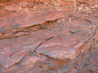
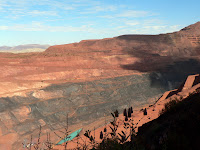
Saturday, 14 July, Auski (Munjina) Roadhouse - This morning we had to go shopping once more in South Hedland for those things we forgot yesterday. Then we left and drove down to this roadhouse (whatever its name), about 250 km from South Hedland. This is at the edge of the Karijini National Park, so we can get there early tomorrow, and hopefully we will get a place to stay at the campground. The landscape has changed as we came closer, interesting rocky ranges, dark brownish red, sometimes even pinkish. Lots of big long road trains and service ute-s on the road, a few oversized vehicles carrying prefabricated houses, huge machinery or whatever. Not as many caravans as before. A lot of mining and construction activity in the area.
 |
| Auski Roadhouse |
 |
| Dales campground |
 |
| Dales Gorge |
 |
| Fern Pool |
 |
| Zebra rocks in Dales Gorge |
 |
| Circular Pool |
 |
| Kalamina Gorge |
 |
| The view above one of the gorges |
 |
| Flowering tree |
 |
| Junction Pool from above |
 |
| Red Gorge from Oxer Lookout |
 |
| The rock face in Hancock Gorge |
We had our lunch at the car park picnic area, then drove back to the Karijini Eco Retreat for a good plunger coffee.
 |
| Joffre Gorge (see the people on the rock face?) |
 |
| Joffre Falls |
 |
| Knox Gorge |
 |
| Sunset at Dales campground |
Tuesday, 17 July, Tom Price caravan park - Yes, the night was better, 8 degrees at sunrise in the van, although the sky was not fully clouded, just a few patches on the East side. The five degrees more made a big difference, but also I put on a few more layers for the night. Then after 7, as the sun went higher, the air has warmed up quite quickly.
 |
| Mount Nameless near Tom Price |
There was a big queue of caravans waiting to get into the park, it was a bit chaotic but finally we got a site and set up the van. It was time again for some household works. Kati did the washing, and I went to wash the car. It was a big job, took 1.5 hours to get rid of all the red dirt in- and outside, but now again we can get in the car without getting dirty.
 |
| The Rio Tinto mine from the top of Mount Nameless |
Wednesday, 18 July, Tom Price caravan park - The night was much warmer than the previous ones, it was 18 degrees in the morning. Not sure why, as we are at about the same elevation. But we don't complain about that.
 |
| A big truck |
 |
| The main pit |
 |
| The processing plant |
Our itinerary can be seen at the following Google Map:
http://g.co/maps/wcwv8
(Note that to see the route after Bowen, you need to move down to the bottom of the right panel, and select the following pages!)
A Pilbara az egy nagyobb tájegység neve Western Australia-ban, a Port Hedland tengerparti vidéke is hozzá tartozik, beljebb pedig a Hammersley Range (hegység). Ez a hegyvidék az ország egyik legfontosabb bányavidéke, foleg vasércet, de mindenféle mást is bányásznak itt több helyen, aztán hordják vasuton és nagy teherautó-konvojokon (road trains) a kikötokbe, onnan meg a világ minden tájára, de mostanában foként Kínába. Emellett sok különleges természeti szépség is van itt, több nemzeti parkban, ezekbol a legnagyobbat látogattuk meg, a Karijini nemzeti parkot.
Szombat reggel indultunk South Hedland-bol, és lejöttünk 260 km-el délebbre, egy Auski (vagy aboriginal nevén Munjina) Roadhouse-hoz, ahol van egy kis kemping is. Az úton rengeteg nagy road train-nel találkoztunk, meg idonként "túlméretes" szállítmányokkal is, amikor le kell húzódni az út szélére amíg elmennek mellettünk. Az egész vidéken látszik hogy milyen intenzív gazdasági és építomunka folyik itt. Délre már odaértünk a roadhouse-hoz, és délután csak ott pihentünk, foztünk, készültünk a következo napokra.
Vasárnap jó korán reggel elindultunk tovább, és bementünk a nemzeti parkba. Korán kellett odaérni hogy nagyobb legyen az esélyünk helyet kapni. Itt a park gondozásában van egy táborhely, ahol érkezési sorrendben lehet bejutni. Azt mondták, hogy sorba kell állni és megvárni amíg ürülnek a helyek. Odamentünk, és nem is volt sor, egybol bejutottunk, kaptunk egy szép táborhelyet. Itt jó tágas helyen megközelíto hurok utak mentén vannak kijelölve számozott táborhelyek jó távol egymástól. Persze ez nem egy kemping, az egyetlen szolgáltatás a wc (pottyantós de nagyon rendes), de minden mással fel vagyunk szerelve. Felállítottuk a lakókocsit, és mindjárt tovább mentünk nézelodni. Ez a vidék (is) a gorge (szurdok? kanyon?)-jairól híres, de egész más mint amiket korábban láttunk. A kozet nagyon érdekes, többnyire tiszta vörös, réteges, fantasztikusak a különbözo színu rétegzodések, ebben vannak az értékes ércfajták. A kozet nagyon régi, 2500 millió éves, és nagyon kemény, de a víz ebbe is mély kanyonokat vágott az idok során, ezek itt a fo látnivaló. Délelott a közeli Dales Gorge-hoz mentünk. Itt egy kilátó pontról láthattunk bele a kanyonba, a rétegezett függoleges sziklafalak közé. A végén volt egy kis vízesés, Fortescue Falls, oda lemásztunk, közelrol is megnéztük, és tovább mentünk a Fern pool-hoz, egy kis természetes tavacskához, amit egy forrás táplál. Aztán felmásztunk, és továbbmentünk a következo kilátó pontig, ahonnan a Circular Pool-ba lehet lelátni. Ez egy köralakú tavacska a kanyon másik végén, több mint 100 m magas függoleges sziklafalak között, fantasztikus látvány. A kanyon fenekén is végig lehet mászni idáig, de azt inkább kihagytuk.
Ebéd után elautóztunk egy másik kanyon-hoz, Kalamina Gorge, itt is lemásztunk az aljára, és jó hosszasan elsétáltunk a fenéken, ez nem volt olyan nehéz, csak egy helyen kellett a vizen átlépkedni. Nemcsak a szuk kanyon, de maga a sziklafal is nagyon érdekes a különbözo színu vizszintes rétegeivel.
Éjszaka nagyon hideg volt. Reggel a lakókocsiban 3 fokot mutatott a homéro. Jól felöltöztünk, de azért így is fáztunk egy kicsit, és felkelni volt a legnehezebb. Aztán 7 óra felé feljött a nap, és elkezdett melegedni. 9-re már megint egy szál ingben lehetett járni.
Hétfon elautóztunk a park másik végébe, kb 60 km földúton, jó poros és rázós, de mit lehet tenni, legalább a lakókocsit nem kellett vinni. Itt 4 kanyon fut össze majdhogynem egy pontban, ezeket néztük meg, többnyire fölülrol. Mindegyik vagy 100 m mély, fantasztikus színes, de dominánsan sötétvörös rétegezett sziklafalak között. Több kilátópont van, amik autóval és egy kis sétával könnyen elérhetok. Azért az egyikbe (Hammresley Gorge) lemásztunk hogy alulról is láthassuk. Déltájban itt egy piknik-helyen ebédeltünk, és egy Eco Retreat nevu intézményben kávéztunk. Délután további két gorge-ot néztünk meg itt, nekem a Joffre Gorge tetszett a legjobban. Itt vagy félórát bámultuk ahogy egy csoport ember lemászott a kanyon másik oldalán a vízeséshez, onnan föntrol nagyon veszélyesnek látszott. Még napnyugta elott visszaértünk a lakókocsihoz, és felállítottuk a zuhanyozó-sátrunkat és jót zuhanyoztunk a saját melegvizünkbol. Ritkán van rá szükség, de akkor nagyon jól jön.
A hétfo éjszaka nem volt annyira hideg, reggel 8 fok, és jobban fel is öltöztünk, nem fáztunk. Kedd reggel összepakoltunk és továbbindultunk. Megint nem messzire, csak 80 km, egy Tom Price nevu kisvárosba. Ez egy bányászati központ, a 1960-as években építették, közvetlenül mellette van egy nagy nyíltszíni bánya. Itt vagyunk most egy kempingben, megint van villany, víz, és fóleg mobil vétel. Kedden foleg háztartási munkákkal voltunk elfoglalva, Kati mosott, és meg lemostam az autót kívül-belül, jó nagy munka volt, de most megint hozzá lehet nyúlni anélkül hogy mindenünk vörös maszatos legyen. Délután kis pihenés után elmentünk kicsit körülnézni. Közvetlenül mögöttünk van egy nagyon impresszív meredek hegy, a Mount Nameless, 1128 m magas, és terepjáróval fel lehet menni a tetejére. Hát, felmentünk, de elég nehéz volt. Nagyon meredek, nagyon keskeny és nagyon egyenetlen, tele éles kövekkel, kicsit izgi volt, de baj nélkül felértünk, és a kilátás valóban nagyon szép, érdemes volt küszködni. Egyik oldalon a nyíltszíni bánya, a másikon a kisváros és további látványos hegyvonulatok. Lefelé még ijesztobb a meredeken, de minden rendben ment, szerencsére az autónk nagyon jól szuperál. Aztán bementünk a városkába, nézelodtünk a turista irodában, és vásároltunk egy kicsit.
Este és éjszaka sokkal melegebb volt mint elozoleg, reggel is 18 fok volt, pedig itt is kb olyan magasan vagyunk, mint a nemzeti parkban, kb 750 m-en. Ma, szerda (jul. 18) délelott elmentünk megnézni a bányát. Egy másfél órás busz-túrával, sok magyarázattal, amibol nagyon keveset értettünk, a vezeto elég elnagyolt artikulálásából, no meg közben a környezetet is kellett figyelni, de nagyon érdekes volt. Óriási gépekkel dolgoznak, eltörpült mellette a buszunk. Hatalmas mély lukat vájtak egy régen volt hegy helyén, negyven éve folyik a kitermelés és még kb húsz évre van mit kiszedni. A kitermelt kozet több mint ötven százaléka tisza vasérc. Azt monta a vezeto, hogy az egész Pilbara vidék az eloxidált vasérctol olyan vörös, mindenhol az van, de ahol kevesebb mint 50% ott nem érdemes kitermelni. Megnéztük a nagy lukat (pit), aztán végighaladtunk a feldolgozó részlegen, ahol zúzzák és osztályozzák a kozetet, aztán vagonokba töltik és viszik a kikötobe. Az egész hatalmas bányamu irányító központja Perth mellett van, innen többezer km-re, onnan kellett a buszvezetonek is engedélyt kérnie az egyes területekre behajtásra. Ez volt a mai összes program, most délután pihenünk, készítem a blogot, és készülünk a következo napokra. Következo uticélunk a tengerparton az ún. Ningalo Reef környéke, egy újabb korall-zátony.
Az útvonalunk a következo Google Map-on látható:
http://g.co/maps/wcwv8
(A Bowen utáni szakaszokhoz le kell menni a jobboldali panel aljára, és a következo oldalakra kattintani!!)

No comments:
Post a Comment